
Պատկեր:Subcarpathia Carpatho-Ukraine.svg

Size of this PNG preview of this SVG file: 688 × 525 պիքսել. Այլ թույլտվությաններ: 315 × 240 պիքսել | 629 × 480 պիքսել | 1007 × 768 պիքսել | 1280 × 977 պիքսել | 2560 × 1953 պիքսել.
Սկզբնական նիշք (SVG-նիշք, անվանապես 688 × 525 փիքսել, նիշքի չափը՝ 105 ԿԲ)
Ամփոփում
| Նկարագրում |
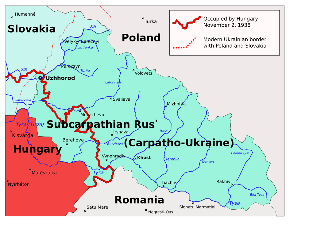
English: Map of the Subcarpathian Rus (1919-1938), that was an autonomous region of the first Czechoslovak Republic; later transformed into the Carpathian Ukraine (1938-1939), that was an autonomous region of the second Czechoslovak Republic, and briefly a self-proclaimed independent state, in March 1939. Own work based on different printed and digital maps.
Polski: Zakarpacie w latach 1938–1939. |
| Թվական | 22 Մարտ 2006 (original upload date) |
| Աղբյուր | No machine-readable source provided. Own work assumed (based on copyright claims). |
| Հեղինակ | No machine-readable author provided. PM assumed (based on copyright claims). |
| Այլ մեկնակերպներ |
|


derivative works
Derivative works of this file:
- Subcarpathia Carpatho-Ukraine uk.svg
- Subcarpathia Carpatho-Ukraine-es.svg
- Subcarpathia Carpatho-Ukraine be.svg
- Carpatho Ukraine March 1939.png
Արտոնագրում
| I, the copyright holder of this work, release this work into the public domain. This applies worldwide. In some countries this may not be legally possible; if so: I grant anyone the right to use this work for any purpose, without any conditions, unless such conditions are required by law. |
Նիշքի պատմություն
Մատնահարեք օրվան/ժամին՝ նիշքի այդ պահին տեսքը դիտելու համար։
| Օր/Ժամ | Մանրապատկեր | Օբյեկտի չափը | Մասնակից | Մեկնաբանություն | |
|---|---|---|---|---|---|
| ընթացիկ | 23:40, 22 Նոյեմբերի 2020 | | 688 × 525 (105 ԿԲ) | Mzajac | copy-edit per sources |
| 23:35, 22 Նոյեմբերի 2020 |  | 688 × 525 (105 ԿԲ) | Mzajac | Copy edit per sources | |
| 22:30, 22 Նոյեմբերի 2020 |  | 688 × 525 (105 ԿԲ) | Mzajac | File uploaded using svgtranslate tool (https://svgtranslate.toolforge.org/). Added translation for en. | |
| 09:24, 2 Նոյեմբերի 2009 |  | 688 × 525 (81 ԿԲ) | Malarz pl | display fix | |
| 00:24, 22 Մարտի 2006 |  | 688 × 525 (89 ԿԲ) | PM | ||
| 00:16, 22 Մարտի 2006 |  | 688 × 525 (89 ԿԲ) | PM | Autonomous Subcarpathian Ruthenia and independent Carpatho-Ukraine 1938-1939. Own work based on different printed and digital maps. Category:Maps of Ukraine |
Նիշքի օգտագործում
Հետևյալ էջը հղվում է այս նիշքին՝
Նիշքի համընդհանուր օգտագործում
Հետևյալ այլ վիքիները օգտագործում են այս նիշքը՝
- Օգտագործումը bg.wikipedia.org կայքում
- Օգտագործումը de.wikipedia.org կայքում
- Օգտագործումը en.wikipedia.org կայքում
- Օգտագործումը eo.wikipedia.org կայքում
- Օգտագործումը fa.wikipedia.org կայքում
- Օգտագործումը fi.wikipedia.org կայքում
- Օգտագործումը fr.wikipedia.org կայքում
- Օգտագործումը it.wikipedia.org կայքում
- Օգտագործումը ka.wikipedia.org կայքում
- Օգտագործումը nl.wikipedia.org կայքում
- Օգտագործումը no.wikipedia.org կայքում
- Օգտագործումը pl.wikipedia.org կայքում
- Użhorod
- Karpato-Ukraina
- Ukraina Karpacka
- Zakarpacie
- Obwód zakarpacki
- Dyskusja wikipedysty:P
- Granica polsko-węgierska
- Dyskusja wikipedysty:Malarz pl/Archiwum/9
- Operacja Łom
- Wikipedysta:Malarz pl/szablony/Państwo infobox/10
- Wikipedysta:Malarz pl/szablony/Państwo infobox
- Wikipedysta:PanGawelek/Rozbiory Czechosłowacji
- Օգտագործումը pt.wikipedia.org կայքում
- Օգտագործումը ro.wikipedia.org կայքում
- Օգտագործումը ru.wikipedia.org կայքում
- Օգտագործումը sh.wikipedia.org կայքում
- Օգտագործումը sl.wikipedia.org կայքում
- Օգտագործումը sr.wikipedia.org կայքում
- Օգտագործումը uk.wikipedia.org կայքում
- Користувач:Alex Blokha/Дні згадані в Вікіпедії/Україна/22 листопада
- Користувач:Alex Blokha/Дні згадані в Вікіпедії/Україна/22 січня
- Користувач:Alex Blokha/Дні згадані в Вікіпедії/Україна/15 березня
- Користувач:Alex Blokha/Дні згадані в Вікіпедії/Україна/18 березня
- Користувач:Alex Blokha/Дні згадані в Вікіпедії/Україна/4 квітня
- Користувач:Alex Blokha/Дні згадані в Вікіпедії/Україна/29 червня
- Лом (операція)
- Польсько-угорський кордон
- Օգտագործումը vi.wikipedia.org կայքում
- Օգտագործումը www.wikidata.org կայքում
- Օգտագործումը zh.wikipedia.org կայքում