
Պատկեր:Quad Flandria.jpg
Նախադիտման չափ՝ 800 × 597 պիքսել։ Այլ թույլտվությաններ: 320 × 239 պիքսել | 640 × 478 պիքսել | 1024 × 765 պիքսել | 1280 × 956 պիքսել | 2560 × 1912 պիքսել | 3345 × 2498 պիքսել.
Սկզբնական նիշք (3345 × 2498 փիքսել, նիշքի չափը՝ 7,53 ՄԲ, MIME-տեսակը՝ image/jpeg)
Ամփոփում
| Description |
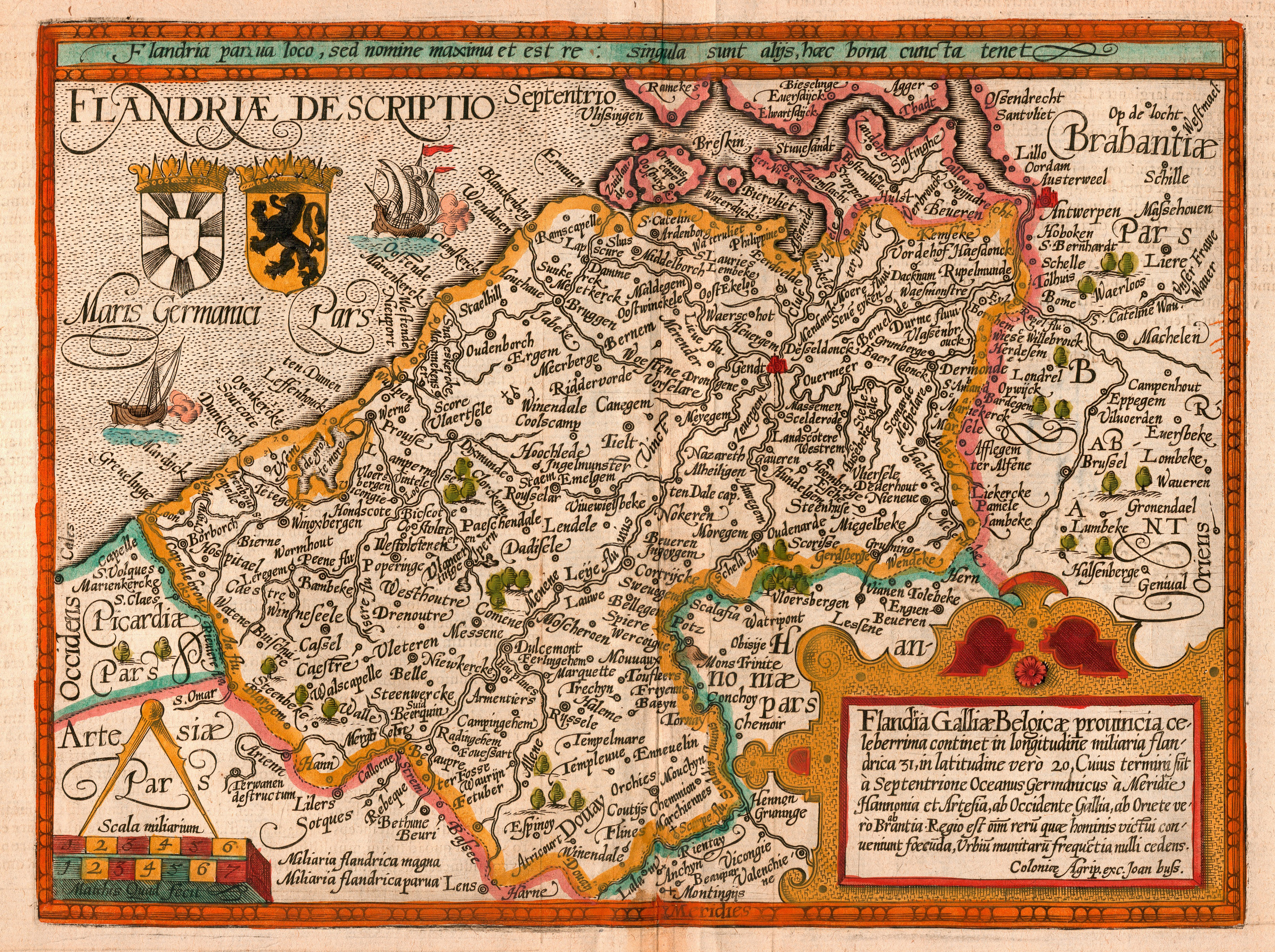
English: Map of the county of Flanders by Matthias Quad (cartographer) and Johannes Bussemacher (engraver & publisher, Cologne)
Nederlands: Kaart van het graafschap Vlaanderen door Matthias Quad (kartograaf) en Johannes Bussemacher (graveur en uitgever, Keulen)
Français : Carte du comté de Flandre par Matthias Quad (cartographe) et Johannes Bussemacher (graveur et éditeur, Cologne)
Español: Mapa del condado de Flandes, de Matthias Quad (cartógrafo) y Johannes Bussemacher (grabador y editor, Colonia, Alemania) |
||||||||||||||||||||||
| Թվական | |||||||||||||||||||||||
| Աղբյուր | eigen werk (scan) | ||||||||||||||||||||||
| Ստեղծել է |
scanned by Marc Ryckaert (MJJR) |
||||||||||||||||||||||
| Իրավունքներ (Նիշքի վերաօգտագործումը) |
|
||||||||||||||||||||||
| Georeferencing | If inappropriate please set warp_status = skip to hide. | ||||||||||||||||||||||
|

Այս պատկերը ընտրված է եղել որպես օրվա պատկեր 6 Մայիս 2008 թվականի համար: Պատկերը ունի հետևյալ նկարագրում՝ English: Map of the county of Flanders by 1609 Այլ լեզուներ՝
Alemannisch: Charte vo Flandern (Belgiä) us em Jahr 1609. Bosanski: Karta Grofovije Flandrija iz 1609. Čeština: Mapa Vévodství Flandry z roku 1609 Dansk: Kort over Flandern (Belgien) i 1609. Deutsch: Karte von Flandern (Belgien) aus dem Jahre 1609. English: Map of the county of Flanders by 1609 Français : Carte de la Flandre Íslenska: Kort af Flandri árið 1609. Italiano: Mappa delle Fiandre del 1609. Magyar: Flandria térképe 1609-ből, Matthias Quad térképész és Johannes Bussemacher grafikus és kiadó (Köln) munkája Polski: Mapa hrabstwa Flandrii wykonana około roku 1609. Svenska: Grevskapet Flandern på en karta från 1609. Türkçe: Flanders kontluğunun 1609'daki haritası Беларуская: Карта Фландрыі (1609) Русский: Карта Фландрии 1609 года Српски / srpski: Мапа Фландрије из 1609. године. Українська: Карта Фландрії 1609 року 한국어: 1609년에 그려진 플란데런 지도. 日本語: 1609年のフランドル地域の地図 中文: 佛兰德伯国1609年地图 中文(繁體): 佛蘭德伯國1609年地圖 العربية : خريطة دولة فلندرز عام 1609. فارسی : نقشه کشور فلندرز در 1609 |
Նիշքի պատմություն
Մատնահարեք օրվան/ժամին՝ նիշքի այդ պահին տեսքը դիտելու համար։
| Օր/Ժամ | Մանրապատկեր | Օբյեկտի չափը | Մասնակից | Մեկնաբանություն | |
|---|---|---|---|---|---|
| ընթացիկ | 20:26, 19 փետրվարի 2008 | | 3345 × 2498 (7,53 ՄԲ) | MJJR | {{Information |Description= {{en|Map of the county of Flanders by Matthias Quad (cartographer) and Johannes Bussemacher (engraver & publisher, Cologne)}} {{nl|Kaart van het graafschap Vlaanderen door Matthias Quad (kartograaf) en Johannes Bussemacher (gra |
| 21:52, 17 փետրվարի 2008 |  | 3345 × 2498 (7,47 ՄԲ) | MJJR | {{Information |Description= {{en|Map of the county of Flanders by Matthias Quad (cartographer) and Johannes Bussemacher (engraver & publisher, Cologne)}} {{nl|Kaart van het graafschap Vlaanderen door Matthias Quad (kartograaf) en Johannes Bussemacher (gra |
Նիշքի օգտագործում
Հետևյալ էջը հղվում է այս նիշքին՝
Նիշքի համընդհանուր օգտագործում
Հետևյալ այլ վիքիները օգտագործում են այս նիշքը՝
- Օգտագործումը af.wikipedia.org կայքում
- Օգտագործումը ast.wikipedia.org կայքում
- Օգտագործումը azb.wikipedia.org կայքում
- Օգտագործումը be-tarask.wikipedia.org կայքում
- Օգտագործումը be.wikipedia.org կայքում
- Օգտագործումը bg.wikipedia.org կայքում
- Օգտագործումը bn.wikipedia.org կայքում
- Օգտագործումը br.wiktionary.org կայքում
- Օգտագործումը ca.wikipedia.org կայքում
- Օգտագործումը crh.wikipedia.org կայքում
- Օգտագործումը cv.wikipedia.org կայքում
- Օգտագործումը da.wikipedia.org կայքում
- Օգտագործումը de.wikipedia.org կայքում
- Օգտագործումը el.wikipedia.org կայքում
- Օգտագործումը en.wikipedia.org կայքում
- Օգտագործումը es.wikipedia.org կայքում
- Օգտագործումը et.wikipedia.org կայքում
- Օգտագործումը frp.wikipedia.org կայքում
- Օգտագործումը fr.wikipedia.org կայքում
Տեսնել այս նիշքի ավելի համընդհանուր օգտագործումը: