
Պատկեր:Prince Edward Island-map.png
Ավելի բարձր կետաչափով տարբերակ չկա։
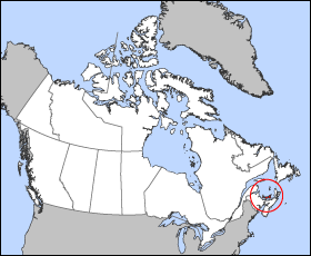
Prince_Edward_Island-map.png (280 × 230 փիքսել, նիշքի չափը՝ 15 ԿԲ, MIME-տեսակը՝ image/png)
Map of Prince Edward Island
Projection: Lambert azimuthal equal-area
Geospatial data from: The Atlas of Canada, The National Atlas of the United States and U.S. Geological Survey
Cartographer: John Fowler
| I, the copyright holder of this work, release this work into the public domain. This applies worldwide. In some countries this may not be legally possible; if so: I grant anyone the right to use this work for any purpose, without any conditions, unless such conditions are required by law. |
Նիշքի պատմություն
Մատնահարեք օրվան/ժամին՝ նիշքի այդ պահին տեսքը դիտելու համար։
| Օր/Ժամ | Մանրապատկեր | Օբյեկտի չափը | Մասնակից | Մեկնաբանություն | |
|---|---|---|---|---|---|
| ընթացիկ | 12:17, 24 Մարտի 2005 | | 280 × 230 (15 ԿԲ) | Voyager | Map of Prince Edward Island Projection: Lambert azimuthal equal-area Geospatial data from: [http://atlas.gc.ca/ The Atlas of Canada], [http://www.nationalatlas.gov/ The National Atlas of the United States] and [http://www.usgs.gov U.S. Geological Survey |
Նիշքի օգտագործում
Հետևյալ էջը հղվում է այս նիշքին՝
Նիշքի համընդհանուր օգտագործում
Հետևյալ այլ վիքիները օգտագործում են այս նիշքը՝
- Օգտագործումը bat-smg.wikipedia.org կայքում
- Օգտագործումը be.wikipedia.org կայքում
- Օգտագործումը br.wikipedia.org կայքում
- Օգտագործումը en.wikipedia.org կայքում
- Օգտագործումը en.wiktionary.org կայքում
- Օգտագործումը eo.wikipedia.org կայքում
- Օգտագործումը fi.wikivoyage.org կայքում
- Օգտագործումը frr.wikipedia.org կայքում
- Օգտագործումը hu.wiktionary.org կայքում
- Օգտագործումը io.wikipedia.org կայքում
- Օգտագործումը ja.wikipedia.org կայքում
- Օգտագործումը ko.wikipedia.org կայքում
- Օգտագործումը kw.wikipedia.org կայքում
- Օգտագործումը lij.wikipedia.org կայքում
- Օգտագործումը mk.wikipedia.org կայքում
- Օգտագործումը nn.wikipedia.org կայքում
- Օգտագործումը pam.wikipedia.org կայքում
- Օգտագործումը pl.wikipedia.org կայքում
- Օգտագործումը pms.wikipedia.org կայքում
- Օգտագործումը ru.wikipedia.org կայքում
- Օգտագործումը sh.wikipedia.org կայքում
- Օգտագործումը simple.wikipedia.org կայքում
- Օգտագործումը sl.wikipedia.org կայքում
- Օգտագործումը uk.wikipedia.org կայքում
- Օգտագործումը vo.wikipedia.org կայքում
- Օգտագործումը xmf.wikipedia.org կայքում
- Օգտագործումը zh-min-nan.wikipedia.org կայքում