
Պատկեր:Nansen Fram Map rus.png
Նախադիտման չափ՝ 800 × 479 պիքսել։ Այլ թույլտվությաններ: 320 × 192 պիքսել | 640 × 383 պիքսել | 1003 × 601 պիքսել.
Սկզբնական նիշք (1003 × 601 փիքսել, նիշքի չափը՝ 84 ԿԲ, MIME-տեսակը՝ image/png)
| Նկարագրում |
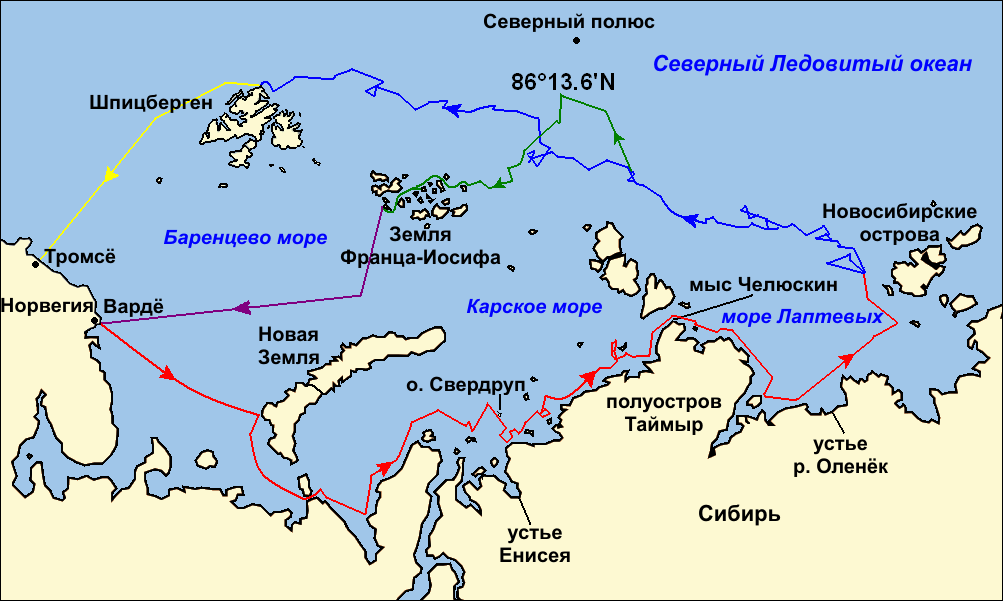
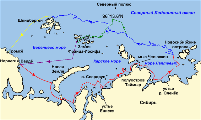
Map of the Arctic Ocean showing the routes taken during the 1893–96 Nansen's Fram expedition: Frams's route eastward from Vardø to the Siberian coast, turning north at the New Siberian Islands to enter the pack ice. July – September 1893 Fram's drift in the ice from the New Siberian Islands, north and west to Spitsbergen, September 1893 – August 1896 Nansen and Johansen's march to Farthest North, 80°20'N, and their subsequent retreat to Cape Flora in Franz Josef Land. February 1895 – June 1896 Nansen and Johansen's return to Vardø from Cape Flora, August 1896 Fram's voyage from Spitsbergen to Tromsø, August 1896 |
| Թվական | (UTC) |
| Աղբյուր | |
| Հեղինակ |
|
| Այլ մեկնակերպներ |
|

| Սա խմբագրված պատկեր է, որը համեմատ բնօրինակին ենթարկվել է թվային մշակման։ Փոփոխությունները՝ текст на русском языке (russian text): Սկզբնական պատկերը գտնվում է այստեղ՝ Nansen Fram Map.png։ Խմբագրել է Ivengo(RUS) մասնակիցը։
|
Ես, այս աշխատանքի հեղինակային իրավունքների տերը, ներկա հրատարակում եմ սրա հետևյալ լիցենզիաների պայմաններով
This file is licensed under the Creative Commons Attribution-Share Alike 3.0 Unported, 2.5 Generic, 2.0 Generic and 1.0 Generic license.
- Դուք ազատ եք՝
- կիսվել ստեղծագործությամբ – պատճենել, տարածել և փոխանցել այս աշխատանքը։
- վերափոխել – ադապտացնել աշխատանքը
- Պահպանելով հետևյալ պայմանները'
- հղում – Դուք պետք է նշեք հեղինակի (իրավատիրոջ) հղումը:
- համանման տարածում – Եթե դուք ձևափոխում եք, փոխակերպում, կամ այս աշխատանքի հիման վրա ստեղծում եք նոր աշխատանք, ապա ձեր ստեղծածը կարող է տարածվել միայն նույն կամ համարժեք թույլատրագրով։

|
Այս վավերագրման պատճենահանման, տարածման և/կամ ձևափոխման թույլտվություն կամ լիցենզիայի GNU FDL պայմաններով 1.2 մեկնակերպի կամ ավելի ուշ, հրատարակված Ազատ ծրագրային ապահովության հիմնադրամում, առանց անփոփոխելի հատվածների, առանց բնագիրների, որոնք տեղադրված են առաջին և վերջին շապիկներում: Լիցենզիայի պատճենը գտնվում է GNU Free Documentation License հատվածում: |
Կարող եք ընտրել այս թույլատրագրերից ցանկացածը։
Original upload log
This image is a derivative work of the following images:
- File:Nansen_Fram_Map.png licensed with Cc-by-sa-3.0,2.5,2.0,1.0, GFDL
- 2009-10-21T15:50:57Z Ruhrfisch 1003x601 (79935 Bytes) Make arrowheads less triangular (indentations at rear)
- 2009-10-21T15:23:20Z Ruhrfisch 1003x601 (79868 Bytes) Add arrowheads per FAC
- 2009-10-20T18:50:18Z Ruhrfisch 1003x601 (79825 Bytes) Make magenta line purple
- 2009-10-11T13:36:40Z Ruhrfisch 1003x601 (79831 Bytes) Yellow line for orange, some labels smaller, Farthest North replaced with actual figure, all other info the same
- 2009-10-11T03:08:59Z Ruhrfisch 1003x601 (81994 Bytes) Darker green for that line, all other information is the same
- 2009-10-11T02:46:31Z Ruhrfisch 1003x601 (81987 Bytes) Added last two lines for ice voyages, added last labels, all other information the same.
- 2009-10-09T19:30:04Z Ruhrfisch 1003x601 (75047 Bytes) Add labels, two more voyage lines, all other information is the same
- 2009-10-09T16:12:36Z Ruhrfisch 1003x601 (57897 Bytes) == Summary == {{Information |Description = Map of the Arctic Ocean showing the path of [[w:Nansen's Fram expedition|Nansen's Fram expedition]] 1893 to 1896 |Source = Base map of European mainland is from [[:File:Ma
Uploaded with derivativeFX
Նիշքի պատմություն
Մատնահարեք օրվան/ժամին՝ նիշքի այդ պահին տեսքը դիտելու համար։
| Օր/Ժամ | Մանրապատկեր | Օբյեկտի չափը | Մասնակից | Մեկնաբանություն | |
|---|---|---|---|---|---|
| ընթացիկ | 23:06, 8 հունվարի 2011 | | 1003 × 601 (84 ԿԲ) | Ivengo(RUS) | {{Information |Description=Map of the Arctic Ocean showing the routes taken during the 1893–96 Nansen's Fram expedition: {{legend|red|Frams's route eastward from Vardø to the Siberian coast, turning north at the New Sibe |
Նիշքի օգտագործում
Հետևյալ էջը հղվում է այս նիշքին՝
Նիշքի համընդհանուր օգտագործում
Հետևյալ այլ վիքիները օգտագործում են այս նիշքը՝
- Օգտագործումը ba.wikipedia.org կայքում
- Օգտագործումը be.wikipedia.org կայքում
- Օգտագործումը bg.wikipedia.org կայքում
- Օգտագործումը kk.wikipedia.org կայքում
- Օգտագործումը ru.wikipedia.org կայքում
- Օգտագործումը uk.wikipedia.org կայքում