
Պատկեր:Metro Brussels.svg

Size of this PNG preview of this SVG file: 800 × 531 պիքսել. Այլ թույլտվությաններ: 320 × 212 պիքսել | 640 × 425 պիքսել | 1024 × 680 պիքսել | 1280 × 850 պիքսել | 2560 × 1699 պիքսել | 1487 × 987 պիքսել.
Սկզբնական նիշք (SVG-նիշք, անվանապես 1487 × 987 փիքսել, նիշքի չափը՝ 1,01 ՄԲ)
Ամփոփում
| Նկարագրում |
Deutsch: Karte des Brüsseler Metronetzes. Die sog. PREMETRO-Linien, die mit dünneren, blauen Linien dargestellt sind, sind unterirdische Straßenbahnstrecken, ähnlich der deutschen Stadtbahnnetze. Diese Strecken setzen sich an der Oberfläche über die hier gezeigten Abschnitte hinaus fort, was aber nicht abgebildet ist. Es existieren noch zwei weitere PREMETRO-Strecken, die allerdings nur jeweils eine Station haben, also habe ich aus Gründen der Übersichtlichkeit davon abgesehen, diese mit darzustellen. Stationen mit zwei Namen haben unterschiedliche Namen im Französischen bzw. Niederländischen. Stationen mit nur einem Namen besitzen keine Entsprechung in der jeweils anderen Sprache, bzw. beide Namen sind gleich.
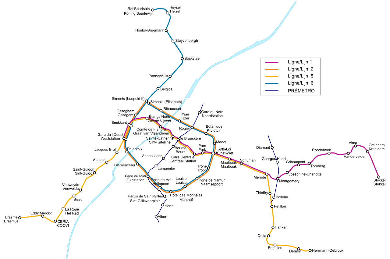
English: Map of the Metro Network of the Belgian capital Brussels. The so called PREMETRO sections, which are shown by blue, thinner lines, are underground sections of the tram network and continue further above ground, which is not shown on the map. There are two more PREMETRO-sections which cover only one station each, so I decided not to display them for a clearer view. Stations with two names have different names in the French and Dutch language. The French name is always shown above the Dutch one. Stations with only one name don't have an expression in the other language or both names are the same.
Français : Plan du réseau de métros de Bruxelles, Belgique. Les sections appelées PRÉMÉTRO, en lignes bleues fines, sont les parties souterraines du réseau de tramways. Elle se poursuivent en surface mais ne sont pas représentées sur la carte. Il y a également deux autres sections de PRÉMÉTRO mais, pour des raisons de clarté, j'ai choisi de ne pas les représenter. Les stations avec deux noms ont un nom différent en français et en néerlandais. Le nom français est toujours situé au dessus du nom néerlandais. Les stations avec un seul nom n'ont pas d'équivalent dans l'autre langue ou bien les deux noms sont identiques.
Nederlands: Kaart van het Brusselse metronet, hoofdstad van België. De zogenaamde PREMETRO-secties, in dunne, blauwe lijnen, zijn ondergrondse tramlijnen die verder lopen boven de grond, wat niet weergegeven wordt op de kaart. Er zijn tevens twee andere secties van de PREMETRO, die elk een station bedienen en niet getekend zijn om de kaart duidelijk te houden. Bij de stations waar de Franse naam verschilt van de Nederlandse, werd het Frans bovenaan geplaatst. |
| Աղբյուր | Բեռնողի սեփական աշխատանք |
| Հեղինակ | L.m.k |
| Այլ մեկնակերպներ |
|


Արտոնագրում
Ես, այս աշխատանքի հեղինակային իրավունքների տերը, ներկա հրատարակում եմ սրա հետևյալ լիցենզիաների պայմաններով

|
Այս վավերագրման պատճենահանման, տարածման և/կամ ձևափոխման թույլտվություն կամ լիցենզիայի GNU FDL պայմաններով 1.2 մեկնակերպի կամ ավելի ուշ, հրատարակված Ազատ ծրագրային ապահովության հիմնադրամում, առանց անփոփոխելի հատվածների, առանց բնագիրների, որոնք տեղադրված են առաջին և վերջին շապիկներում: Լիցենզիայի պատճենը գտնվում է GNU Free Documentation License հատվածում: |
| Այս նիշքը հասանելի է Creative Commons Attribution-Share Alike 3.0 Unported արտոնագրի ներքո: | ||
| ||
| Այս արտոնգրության հատկանիշը ավելացված է տվյալ նիշքին որպես GFDL արտոնագրի բարեփոխում: |
This file is licensed under the Creative Commons Attribution-Share Alike 2.5 Generic, 2.0 Generic and 1.0 Generic license.
- Դուք ազատ եք՝
- կիսվել ստեղծագործությամբ – պատճենել, տարածել և փոխանցել այս աշխատանքը։
- վերափոխել – ադապտացնել աշխատանքը
- Պահպանելով հետևյալ պայմանները'
- հղում – Դուք պետք է նշեք հեղինակի (իրավատիրոջ) հղումը:
- համանման տարածում – Եթե դուք ձևափոխում եք, փոխակերպում, կամ այս աշխատանքի հիման վրա ստեղծում եք նոր աշխատանք, ապա ձեր ստեղծածը կարող է տարածվել միայն նույն կամ համարժեք թույլատրագրով։
Կարող եք ընտրել այս թույլատրագրերից ցանկացածը։
Նիշքի պատմություն
Մատնահարեք օրվան/ժամին՝ նիշքի այդ պահին տեսքը դիտելու համար։
| Օր/Ժամ | Մանրապատկեր | Օբյեկտի չափը | Մասնակից | Մեկնաբանություն | |
|---|---|---|---|---|---|
| ընթացիկ | 21:34, 2 Մայիսի 2009 | | 1487 × 987 (1,01 ՄԲ) | M0tty | Correction orthographe + taille police |
| 22:34, 1 Մայիսի 2009 |  | 1457 × 992 (1,01 ՄԲ) | M0tty | corrections orthographiques | |
| 21:59, 24 Ապրիլի 2009 |  | 1457 × 992 (1,01 ՄԲ) | M0tty | Change on new metro | |
| 08:51, 11 Սեպտեմբերի 2007 |  | 1457 × 992 (105 ԿԲ) | Poulpy | Gare Cantrale -> Gare Centrale | |
| 00:39, 18 Նոյեմբերի 2006 |  | 1457 × 992 (105 ԿԲ) | L.m.k | Added new line section | |
| 00:50, 12 Նոյեմբերի 2005 |  | 1457 × 992 (127 ԿԲ) | L.m.k | A station name wasn't aligned correctly. Now it is! | |
| 00:41, 12 Նոյեմբերի 2005 |  | 1457 × 992 (127 ԿԲ) | L.m.k | {{en|Map of the Metro Network of the Belgian capital Brussels. The so called PREMETRO sections, which are shown by blue, thinner lines, are underground sections of the tram network and countinue further above ground, which is not shown on the map. There a |
Նիշքի օգտագործում
Հետևյալ էջը հղվում է այս նիշքին՝
Նիշքի համընդհանուր օգտագործում
Հետևյալ այլ վիքիները օգտագործում են այս նիշքը՝
- Օգտագործումը ar.wikipedia.org կայքում
- Օգտագործումը ba.wikipedia.org կայքում
- Օգտագործումը be-tarask.wikipedia.org կայքում
- Օգտագործումը bg.wikipedia.org կայքում
- Օգտագործումը bn.wikipedia.org կայքում
- Օգտագործումը ca.wikipedia.org կայքում
- Օգտագործումը cs.wikipedia.org կայքում
- Օգտագործումը cv.wikipedia.org կայքում
- Օգտագործումը da.wikipedia.org կայքում
- Օգտագործումը de.wikipedia.org կայքում
- Օգտագործումը el.wikipedia.org կայքում
- Օգտագործումը en.wikipedia.org կայքում
- Օգտագործումը eo.wikipedia.org կայքում
- Օգտագործումը es.wikipedia.org կայքում
- Օգտագործումը et.wikipedia.org կայքում
- Օգտագործումը eu.wikipedia.org կայքում
- Օգտագործումը fa.wikipedia.org կայքում
- Օգտագործումը fi.wikipedia.org կայքում
- Օգտագործումը fr.wikipedia.org կայքում
- Métro de Bruxelles
- Liste des stations du métro de Bruxelles
- Prémétro de Bruxelles
- Discussion utilisateur:TravauxSTIB
- Wikipédia:Atelier graphique/Images à améliorer/Archives/Avril 2009
- Wikipédia:Atelier graphique/Images à améliorer/Archives/Mai 2009
- Utilisateur:-Strogoff-/Archives 2009
- Utilisateur:Vascer/Brouillon2
- Օգտագործումը fr.wikivoyage.org կայքում
- Օգտագործումը fy.wikipedia.org կայքում
- Օգտագործումը hr.wikipedia.org կայքում
- Օգտագործումը hu.wikipedia.org կայքում
- Օգտագործումը it.wikipedia.org կայքում
- Օգտագործումը it.wikivoyage.org կայքում
- Օգտագործումը ka.wikipedia.org կայքում
- Օգտագործումը ko.wikipedia.org կայքում
- Օգտագործումը ku.wikipedia.org կայքում
- Օգտագործումը lb.wikipedia.org կայքում
Տեսնել այս նիշքի ավելի համընդհանուր օգտագործումը: