
Պատկեր:Map missoula floods.gif
Ավելի բարձր կետաչափով տարբերակ չկա։
Map_missoula_floods.gif (668 × 481 փիքսել, նիշքի չափը՝ 24 ԿԲ, MIME-տեսակը՝ image/gif)
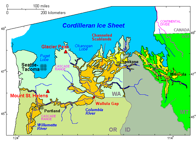
Legend
Cordilleran Ice Sheet
maximum extent of Glacial Lake Missoula (eastern) and Glacial Lake Columbia (western)
areas swept by Missoula and Columbia floods
Ամփոփում
| Նկարագրում | Map of the Missoula Floods |
| Աղբյուր | http://vulcan.wr.usgs.gov/Volcanoes/ColumbiaPlateau/summary_columbia_plateau.html |
| Հեղինակ | USGS |
| Իրավունքներ (Նիշքի վերաօգտագործումը) |
public domain |

|
This map image could be re-created using vector graphics as an SVG file. This has several advantages; see Commons:Media for cleanup for more information. If an SVG form of this image is available, please upload it and afterwards replace this template with
{{vector version available|new image name}}.
It is recommended to name the SVG file “Map missoula floods.svg”—then the template Vector version available (or Vva) does not need the new image name parameter. |
Արտոնագրում
This image is in the public domain in the United States because it only contains materials that originally came from the United States Geological Survey, an agency of the United States Department of the Interior. For more information, see the official USGS copyright policy.
|
Նիշքի պատմություն
Մատնահարեք օրվան/ժամին՝ նիշքի այդ պահին տեսքը դիտելու համար։
| Օր/Ժամ | Մանրապատկեր | Օբյեկտի չափը | Մասնակից | Մեկնաբանություն | |
|---|---|---|---|---|---|
| ընթացիկ | 00:40, 6 Սեպտեմբերի 2009 | | 668 × 481 (24 ԿԲ) | Peteforsyth | moved scale of miles/km; cropped out now-redundant legend. |
| 00:26, 6 Սեպտեմբերի 2009 |  | 668 × 594 (26 ԿԲ) | Peteforsyth | trimmed it | |
| 02:12, 18 Օգոստոսի 2009 |  | 680 × 700 (30 ԿԲ) | Peteforsyth | {{Information |Description=Map of the Missoula Floods |Source=http://vulcan.wr.usgs.gov/Volcanoes/ColumbiaPlateau/summary_columbia_plateau.html |Date= |Author=USGS |Permission=public domain |other_versions= }} |
Նիշքի օգտագործում
Հետևյալ էջը հղվում է այս նիշքին՝
Նիշքի համընդհանուր օգտագործում
Հետևյալ այլ վիքիները օգտագործում են այս նիշքը՝
- Օգտագործումը ca.wikipedia.org կայքում
- Օգտագործումը de.wikipedia.org կայքում
- Օգտագործումը en.wikipedia.org կայքում
- Օգտագործումը es.wikipedia.org կայքում
- Օգտագործումը fr.wikipedia.org կայքում
- Օգտագործումը he.wikipedia.org կայքում
- Օգտագործումը it.wikipedia.org կայքում
- Օգտագործումը kw.wikipedia.org կայքում
- Օգտագործումը pl.wikipedia.org կայքում
- Օգտագործումը ru.wikipedia.org կայքում
- Օգտագործումը uk.wikipedia.org կայքում