
Պատկեր:Map Anatolia ancient regions-en.svg

Սկզբնական նիշք (SVG-նիշք, անվանապես 921 × 596 փիքսել, նիշքի չափը՝ 256 ԿԲ)
| Նկարագրում |
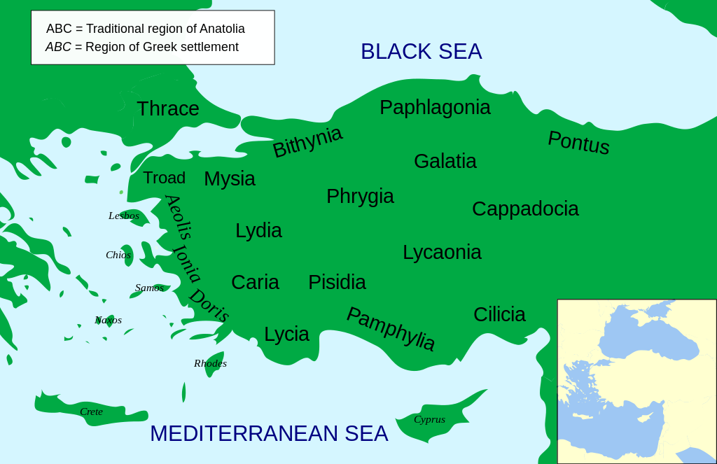
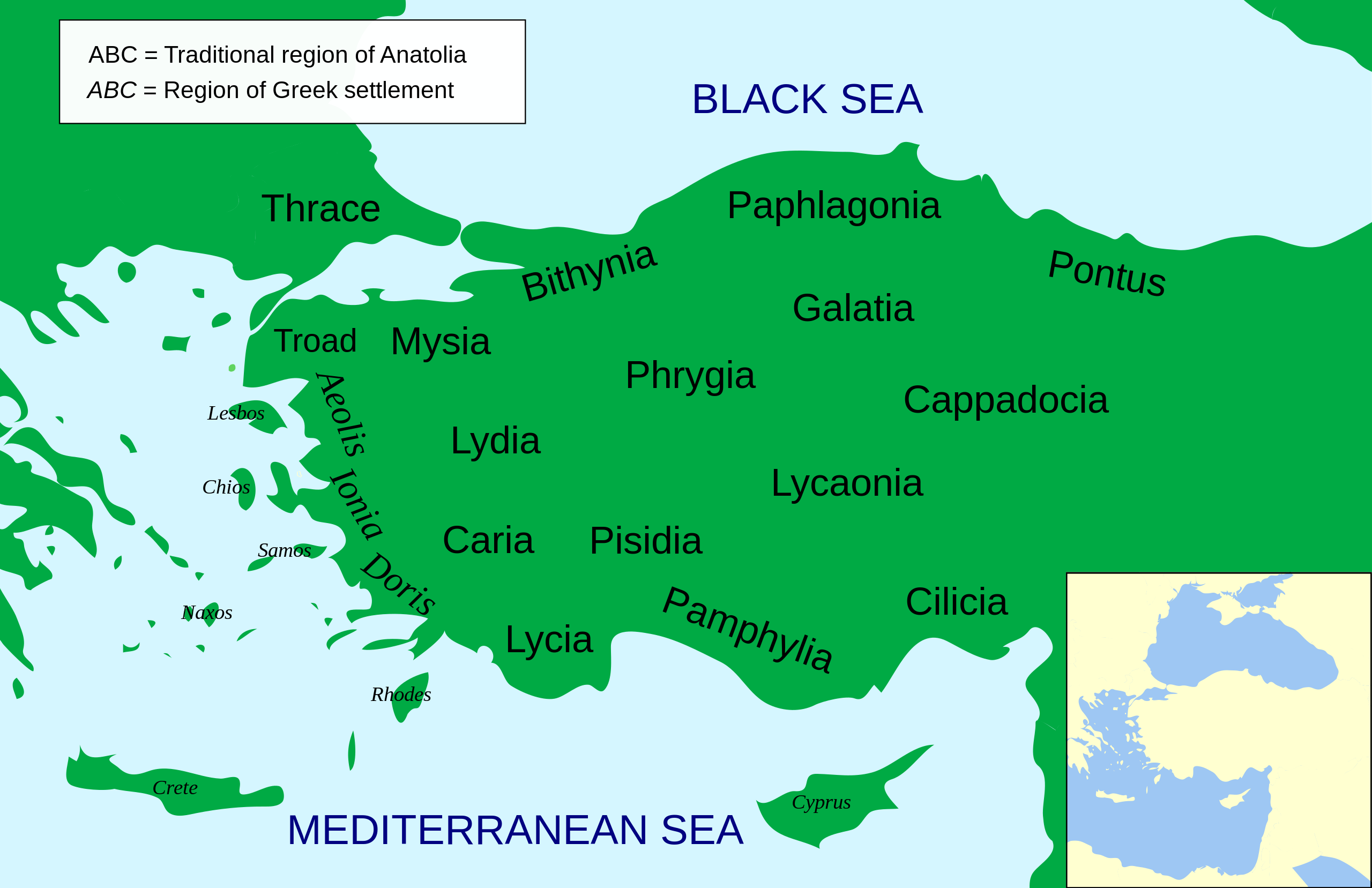
Català: Mapa regional d'Àsia Menor al segle II aC
English: Regional map of Asia Minor in the 2nd Century BC |
| Թվական | (UTC) |
| Աղբյուր | |
| Հեղինակ |
|
| Այլ մեկնակերպներ |
Other related versions: []
Derivative works of this file: |


.svg)


|
Այս SVG ֆայլ օգտագործում է զետեղված տեքստ, որը կարելի է հեշտ թարգմանել ձեր լեզվի վրա using [toolforge:svgtranslate/File:Map_Anatolia_ancient_regions-en.svglink this automated tool]: Իմացեք ավելին: You can also download it and translate it manually using a text editor. |
This file is translated using SVG For most Wikipedia projects, you can embed the file normally (without a To translate the text into your language, you can use the SVG Translate tool. Alternatively, you can download the file to your computer, add your translations using whatever software you're familiar with, and re-upload it with the same name. You will find help in Graphics Lab if you're not sure how to do this. |
| Սա խմբագրված պատկեր է, որը համեմատ բնօրինակին ենթարկվել է թվային մշակման։ Փոփոխությունները՝ Increased legibility, slight corrections in position: Սկզբնական պատկերը գտնվում է այստեղ՝ Asia Minor Political 500BC.svg։ Խմբագրել է MinisterForBadTimes մասնակիցը։
|
- Դուք ազատ եք՝
- կիսվել ստեղծագործությամբ – պատճենել, տարածել և փոխանցել այս աշխատանքը։
- վերափոխել – ադապտացնել աշխատանքը
- Պահպանելով հետևյալ պայմանները'
- հղում – Դուք պետք է նշեք հեղինակի (իրավատիրոջ) հղումը:
- համանման տարածում – Եթե դուք ձևափոխում եք, փոխակերպում, կամ այս աշխատանքի հիման վրա ստեղծում եք նոր աշխատանք, ապա ձեր ստեղծածը կարող է տարածվել միայն նույն կամ համարժեք թույլատրագրով։

|
Այս վավերագրման պատճենահանման, տարածման և/կամ ձևափոխման թույլտվություն կամ լիցենզիայի GNU FDL պայմաններով 1.2 մեկնակերպի կամ ավելի ուշ, հրատարակված Ազատ ծրագրային ապահովության հիմնադրամում, առանց անփոփոխելի հատվածների, առանց բնագիրների, որոնք տեղադրված են առաջին և վերջին շապիկներում: Լիցենզիայի պատճենը գտնվում է GNU Free Documentation License հատվածում: |
Original upload log
This image is a derivative work of the following images:
- File:Asia_Minor_Political_500BC.svg licensed with Cc-by-sa-3.0, GFDL
- 2009-04-22T07:38:42Z MinisterForBadTimes 921x596 (283615 Bytes) Coloured in rogue region
- 2009-04-22T07:36:20Z MinisterForBadTimes 921x596 (283353 Bytes) Changed fonts...again
- 2009-04-22T07:33:39Z MinisterForBadTimes 921x596 (283414 Bytes) Changed fonts
- 2009-04-22T07:25:50Z MinisterForBadTimes 921x596 (284262 Bytes) {{Information |Description={{en|1= Political map of Asia Minor in 500 BC}} |Source=*[[:File:Mysia.svg|]] |Date=2009-04-22 08:23 (UTC) |Author=*[[:File:Mysia.svg|]]: [[User:Emok|Emok]] *derivative work: *[[:Image:Mysia_map_anc
Uploaded with derivativeFX
Նիշքի պատմություն
Մատնահարեք օրվան/ժամին՝ նիշքի այդ պահին տեսքը դիտելու համար։
| Օր/Ժամ | Մանրապատկեր | Օբյեկտի չափը | Մասնակից | Մեկնաբանություն | |
|---|---|---|---|---|---|
| ընթացիկ | 14:14, 15 փետրվարի 2024 | | 921 × 596 (256 ԿԲ) | Manlleus | File uploaded using svgtranslate tool (https://svgtranslate.toolforge.org/). Added translation for ca. |
| 14:01, 15 փետրվարի 2024 |  | 921 × 596 (235 ԿԲ) | Manlleus | fixed text labels for translation | |
| 19:48, 23 Ապրիլի 2009 |  | 921 × 596 (278 ԿԲ) | MinisterForBadTimes | Added Galatia, minor other changes | |
| 16:01, 22 Ապրիլի 2009 |  | 921 × 596 (277 ԿԲ) | MinisterForBadTimes | {{Information |Description={{en|1= Political map of Asia Minor in 500 BC}} |Source=*File:Asia_Minor_Political_500BC.svg |Date=2009-04-22 17:00 (UTC) |Author=*File:Asia_Minor_Political_500BC.svg: *Mysia.svg: [[User:Emok|Emok |
Նիշքի օգտագործում
Հետևյալ 3 էջերը հղվում են այս նիշքին՝
Նիշքի համընդհանուր օգտագործում
Հետևյալ այլ վիքիները օգտագործում են այս նիշքը՝
- Օգտագործումը af.wikipedia.org կայքում
- Օգտագործումը als.wikipedia.org կայքում
- Օգտագործումը am.wikipedia.org կայքում
- Օգտագործումը ar.wikipedia.org կայքում
- Օգտագործումը azb.wikipedia.org կայքում
- Օգտագործումը az.wikipedia.org կայքում
- Օգտագործումը be-tarask.wikipedia.org կայքում
- Օգտագործումը bg.wikipedia.org կայքում
- Օգտագործումը bn.wikipedia.org կայքում
- Օգտագործումը br.wikipedia.org կայքում
- Օգտագործումը bs.wikipedia.org կայքում
- Օգտագործումը ca.wikipedia.org կայքում
- Օգտագործումը cs.wikipedia.org կայքում
- Օգտագործումը da.wikipedia.org կայքում
- Օգտագործումը de.wikipedia.org կայքում
- Օգտագործումը diq.wikipedia.org կայքում
- Օգտագործումը en.wikipedia.org կայքում
Տեսնել այս նիշքի ավելի համընդհանուր օգտագործումը: