
Պատկեր:Kosovo map-en.svg

Size of this PNG preview of this SVG file: 582 × 599 պիքսել. Այլ թույլտվությաններ: 233 × 240 պիքսել | 466 × 480 պիքսել | 746 × 768 պիքսել | 994 × 1024 պիքսել | 1989 × 2048 պիքսել | 1777 × 1830 պիքսել.
Սկզբնական նիշք (SVG-նիշք, անվանապես 1777 × 1830 փիքսել, նիշքի չափը՝ 3,81 ՄԲ)
Ամփոփում
| Description |
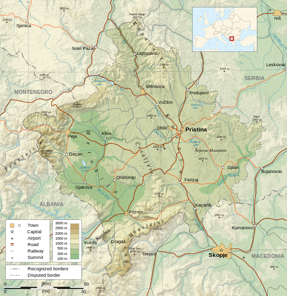
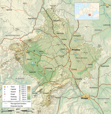
Čeština: Mapa Kosova. Dansk: Kort over Kosovo. Deutsch: Karte des Kosovo. English: Map of the Kosovo. Español: Mapa de Kosovo. Français : Carte du Kosovo, en anglais. Italiano: Mappa del Kosovo. Magyar: Koszovó térképe albán és szerb helységnevekkel. Polski: Mapa Kosowa. Română: Harta provinciei Kosovo Svenska: Karta över Kosovo, engelskspråkig. Türkçe: Kosova haritası. Македонски: Карта на Косово на англиски. Русский: Карта Косово, на английском. Українська: Карта Косово 日本語: コソボの地図。 |
||||||
| Թվական | |||||||
| Աղբյուր |
Own work. Sources :
Software used :
Other data :
|
||||||
| Ստեղծել է | |||||||
| Georeferencing | If inappropriate please set warp_status = skip to hide. | ||||||
| Այլ մեկնակերպներ |
[] | ||||||
| Հղում (required by the license) | © Sémhur / Wikimedia Commons / | ||||||
| Assessments |
|
||||||
| SVG | W3C-validity not checked. Սա վեկտոր գրաֆիկական պատկեր է ստեղծված է եղել Inkscape օգնությամբ: .
|
||||||
| Graphic Lab |


| Տեսախցիկի տեղագրություն | | Այս և ուրիշ պատկերներ իրենց տեղագրությամբ OpenStreetMap |
|---|
Արտոնագրում
Ես, այս աշխատանքի հեղինակային իրավունքների տերը, ներկա հրատարակում եմ սրա հետևյալ լիցենզիաների պայմաններով
| Copyleft: This work of art is free; you can redistribute it and/or modify it according to terms of the Free Art License. You will find a specimen of this license on the Copyleft Attitude site as well as on other sites. |
This file is licensed under the Creative Commons Attribution-Share Alike 4.0 International, 3.0 Unported, 2.5 Generic, 2.0 Generic and 1.0 Generic license.
- Դուք ազատ եք՝
- կիսվել ստեղծագործությամբ – պատճենել, տարածել և փոխանցել այս աշխատանքը։
- վերափոխել – ադապտացնել աշխատանքը
- Պահպանելով հետևյալ պայմանները'
- հղում – Դուք պետք է նշեք հեղինակի (իրավատիրոջ) հղումը:
- համանման տարածում – Եթե դուք ձևափոխում եք, փոխակերպում, կամ այս աշխատանքի հիման վրա ստեղծում եք նոր աշխատանք, ապա ձեր ստեղծածը կարող է տարածվել միայն նույն կամ համարժեք թույլատրագրով։
Կարող եք ընտրել այս թույլատրագրերից ցանկացածը։
Նիշքի պատմություն
Մատնահարեք օրվան/ժամին՝ նիշքի այդ պահին տեսքը դիտելու համար։
| Օր/Ժամ | Մանրապատկեր | Օբյեկտի չափը | Մասնակից | Մեկնաբանություն | |
|---|---|---|---|---|---|
| ընթացիկ | 14:35, 21 Սեպտեմբերի 2023 | | 1777 × 1830 (3,81 ՄԲ) | Socialdilema | File uploaded using svgtranslate tool (https://svgtranslate.toolforge.org/). Added translation for ca. |
| 18:41, 12 Մայիսի 2021 |  | 1777 × 1830 (3,74 ՄԲ) | Uniacademic | Same as the previous edit. | |
| 18:28, 12 Մայիսի 2021 |  | 1777 × 1830 (3,74 ՄԲ) | Uniacademic | Updated the names of cities in cases where WP:COMMONNAME has changed since 2008. | |
| 09:14, 5 Մարտի 2008 |  | 1777 × 1830 (3,75 ՄԲ) | Sémhur | Added borders, with keys (recognized - disputed) | |
| 09:16, 4 Մարտի 2008 |  | 1777 × 1830 (3,74 ՄԲ) | Sémhur | Remove Kosovo boundaries to neutralize the map, + labels more readable | |
| 14:45, 3 Մարտի 2008 |  | 1777 × 1830 (3,74 ՄԲ) | Sémhur | Correcting few labels | |
| 19:15, 28 փետրվարի 2008 |  | 1777 × 1830 (3,74 ՄԲ) | Sémhur | minor changes | |
| 11:37, 26 փետրվարի 2008 |  | 1777 × 1830 (3,74 ՄԲ) | Sémhur | == Description == {{Information |Description= {{en| Map of the Kosovo.}} {{fr| Carte du Kosovo, en anglais.}} |Source=Own work. {{clr}} Sources : * Topographic background : [http://www2.jpl.nasa.gov/srtm NASA Shuttle Radar To |
Նիշքի օգտագործում
Հետևյալ էջը հղվում է այս նիշքին՝
Նիշքի համընդհանուր օգտագործում
Հետևյալ այլ վիքիները օգտագործում են այս նիշքը՝
- Օգտագործումը af.wikipedia.org կայքում
- Օգտագործումը ar.wikipedia.org կայքում
- Օգտագործումը az.wikipedia.org կայքում
- Օգտագործումը bcl.wikipedia.org կայքում
- Օգտագործումը be-tarask.wikipedia.org կայքում
- Օգտագործումը bg.wikipedia.org կայքում
- Օգտագործումը de.wikipedia.org կայքում
- Օգտագործումը de.wikibooks.org կայքում
- Օգտագործումը en.wikipedia.org կայքում
- Օգտագործումը es.wikipedia.org կայքում
- Օգտագործումը fa.wikipedia.org կայքում
- Օգտագործումը fi.wikipedia.org կայքում
- Օգտագործումը fr.wikipedia.org կայքում
- Օգտագործումը fr.wikinews.org կայքում
- Օգտագործումը ga.wikipedia.org կայքում
- Օգտագործումը gl.wikipedia.org կայքում
- Օգտագործումը gv.wikipedia.org կայքում
- Օգտագործումը is.wikipedia.org կայքում
- Օգտագործումը ko.wikipedia.org կայքում
- Օգտագործումը lt.wikipedia.org կայքում
- Օգտագործումը mg.wikipedia.org կայքում
- Օգտագործումը ml.wikipedia.org կայքում
- Օգտագործումը mr.wikipedia.org կայքում
- Օգտագործումը mzn.wikipedia.org կայքում
- Օգտագործումը nn.wikipedia.org կայքում
- Օգտագործումը no.wikipedia.org կայքում
- Օգտագործումը pa.wikipedia.org կայքում
Տեսնել այս նիշքի ավելի համընդհանուր օգտագործումը: