
Պատկեր:Harricana map.png
Ավելի բարձր կետաչափով տարբերակ չկա։
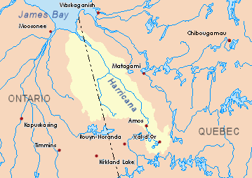
Harricana_map.png (359 × 254 փիքսել, նիշքի չափը՝ 19 ԿԲ, MIME-տեսակը՝ image/png)
Ամփոփում
| Նկարագրում |
English: Drainage basin of the Harricana River, Quebec and Ontario, Canada. |
| Աղբյուր | Own work based on info from Atlas of Canada |
| Հեղինակ | P199 |
Արտոնագրում
| I, the copyright holder of this work, release this work into the public domain. This applies worldwide. In some countries this may not be legally possible; if so: I grant anyone the right to use this work for any purpose, without any conditions, unless such conditions are required by law. |
Նիշքի պատմություն
Մատնահարեք օրվան/ժամին՝ նիշքի այդ պահին տեսքը դիտելու համար։
| Օր/Ժամ | Մանրապատկեր | Օբյեկտի չափը | Մասնակից | Մեկնաբանություն | |
|---|---|---|---|---|---|
| ընթացիկ | 23:49, 23 Նոյեմբերի 2008 | | 359 × 254 (19 ԿԲ) | P199 | {{Information |Description={{en|1=Drainage basin of the Harricana River, Quebec and Ontario, Canada.}} |Source=Own work based on info from [http://atlas.nrcan.gc.ca/site/english/maps/environment/hydrology/drainagebasins Atlas of Canada] |Author=[[User:P19 |
Նիշքի օգտագործում
Հետևյալ էջը հղվում է այս նիշքին՝
Նիշքի համընդհանուր օգտագործում
Հետևյալ այլ վիքիները օգտագործում են այս նիշքը՝
- Օգտագործումը arz.wikipedia.org կայքում
- Օգտագործումը bg.wikipedia.org կայքում
- Օգտագործումը ceb.wikipedia.org կայքում
- Օգտագործումը de.wikipedia.org կայքում
- Օգտագործումը en.wikipedia.org կայքում
- Harricana River
- Breynat River
- Again River
- Corner River
- Turgeon River (Harricana River tributary)
- Detour River
- Garneau River
- Turcotte River
- Burntbush River
- Patten River
- Little Turcotte River
- Chabbie River
- Mikwam River
- East Mikwam River
- Little Mikwam River
- Kabika River
- East Kabika River
- Case River
- Kenning River
- North Burntbush River
- South Patten River
- Boivin River
- Théo River
- Lavergne River
- Lake Turgeon
- Wawagosic River
- Ojima River
- Enjalran River
- Corset River
- Malouin River
- Mannerelle River
- Despreux River
- Menard River
- Mistaouac River
- Kadabakato River
- Trudelle River
- Perdrix River (Eeyou Istchee Baie-James)
- Tangente River
- Martigny River
- Novide River
- Davoust River
- Օգտագործումը fr.wikipedia.org կայքում
Տեսնել այս նիշքի ավելի համընդհանուր օգտագործումը: