
Պատկեր:Great Basin map.gif

Նախադիտման չափ՝ 537 × 600 պիքսել։ Այլ թույլտվությաններ: 215 × 240 պիքսել | 430 × 480 պիքսել | 687 × 768 պիքսել | 1074 × 1200 պիքսել.
Սկզբնական նիշք (1074 × 1200 փիքսել, նիշքի չափը՝ 342 ԿԲ, MIME-տեսակը՝ image/gif, 0,1 վ)
Ամփոփում
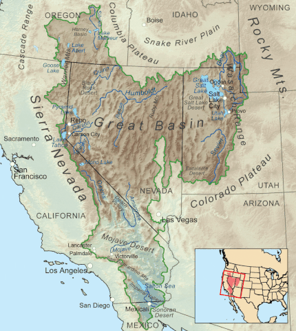
| Նկարագրում | Map showing the Great Basin drainage basin as defined hydrologically. |
| Թվական | (UTC) |
| Աղբյուր |
This file was derived from: Greatbasinmap.png:  |
| Հեղինակ |
|
Արտոնագրում
Kmusser at Վիքիպահեստ, սույն աշխատանքի հեղինակային իրավունքների տերը, այսուհետ այն հրատարակում է հետևյալ արտոնագրի պայմաններով՝
Այս նիշքը հասանելի է Creative Commons Attribution-Share Alike 3.0 Unported արտոնագրի ներքո:
Հղում: Kmusser at Վիքիպահեստ
- Դուք ազատ եք՝
- կիսվել ստեղծագործությամբ – պատճենել, տարածել և փոխանցել այս աշխատանքը։
- վերափոխել – ադապտացնել աշխատանքը
- Պահպանելով հետևյալ պայմանները'
- հղում – Դուք պետք է նշեք հեղինակի (իրավատիրոջ) հղումը:
- համանման տարածում – Եթե դուք ձևափոխում եք, փոխակերպում, կամ այս աշխատանքի հիման վրա ստեղծում եք նոր աշխատանք, ապա ձեր ստեղծածը կարող է տարածվել միայն նույն կամ համարժեք թույլատրագրով։
Original upload log
This image is a derivative work of the following images:
- File:Greatbasinmap.png licensed with Cc-by-sa-3.0
- 2020-09-04T22:25:15Z Nwbeeson 1500x1676 (7565343 Bytes) Added boundary map. Second attempt to upload the image.
- 2020-09-04T22:21:06Z Nwbeeson 1500x1676 (7564895 Bytes) Added boundary line.
- 2010-12-11T16:58:55Z Kmusser 1500x1676 (3820728 Bytes) Added Goose Lake
- 2010-11-17T20:37:07Z Kmusser 1500x1676 (3382394 Bytes) == Summary == {{Information |Description=Map showing the [[:w:Great Basin|Great Basin]] drainage basin as defined hydrologically. |Source={{own}}, Elevation data from [[:w:Shuttle Radar Topography Mission|SRTM]], all other fe
Uploaded with derivativeFX
Նիշքի պատմություն
Մատնահարեք օրվան/ժամին՝ նիշքի այդ պահին տեսքը դիտելու համար։
| Օր/Ժամ | Մանրապատկեր | Օբյեկտի չափը | Մասնակից | Մեկնաբանություն | |
|---|---|---|---|---|---|
| ընթացիկ | 22:05, 7 Մայիսի 2022 | | 1074 × 1200 (342 ԿԲ) | Hike395 | == {{int:filedesc}} == {{Information |Description=Map showing the Great Basin drainage basin as defined hydrologically. |Source={{Derived from|Greatbasinmap.png|display=50}} |Date=2022-05-07 22:03 (UTC) |Author=* File:Greatbasinmap.png: Kmusser * conversion to gif: [[User:{{subst:REVISIONUSER}}|{{subst:REVISIONUSER}}]] |Permission= |other_versions= }} == {{int:license-header}} == {{self|author={{user at project|Kmusser|c}}|Cc-by... |
Նիշքի օգտագործում
Հետևյալ էջը հղվում է այս նիշքին՝
Նիշքի համընդհանուր օգտագործում
Հետևյալ այլ վիքիները օգտագործում են այս նիշքը՝
- Օգտագործումը en.wikipedia.org կայքում
- List of rivers of the Americas
- Great Basin
- Rain shadow
- Geology of the United States
- List of rivers of the Great Basin
- Bear River (Great Salt Lake)
- Talk:Great Basin
- Weber River
- List of deserts by area
- Fish Lake Valley
- Dixie Valley
- List of Great Basin watersheds
- Template:Great Basin watersheds
- Great Basin Divide
- Antelope Valley (Eureka County)
- Indian Springs Pass
- Antelope Valley (southwest Millard County, Utah)
- User:Mmcannis/sandbox/McCullough Range south Triple Point (water divide)
- User:Mmcannis/sandbox/Original-New York Mountains north divide
- User:Mmcannis/sandbox/Indian Springs Pass
- Numaga
- Օգտագործումը fi.wikipedia.org կայքում
- Օգտագործումը ro.wikipedia.org կայքում
- Օգտագործումը si.wikipedia.org կայքում
- Օգտագործումը www.wikidata.org կայքում