
Պատկեր:First republic of Armenia-west borders by Woodrow Wilson.png
Ավելի բարձր կետաչափով տարբերակ չկա։
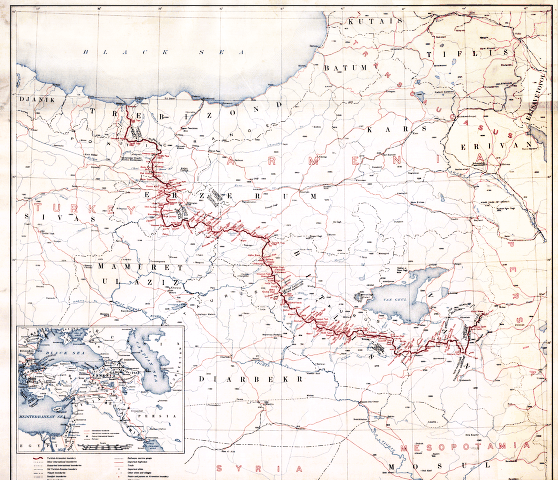
First_republic_of_Armenia-west_borders_by_Woodrow_Wilson.png (558 × 480 փիքսել, նիշքի չափը՝ 464 ԿԲ, MIME-տեսակը՝ image/png)
Ամփոփում
American memory collection http://hdl.loc.gov/loc.gmd/g7431f.ct000197
hi-res file is available at File:Boundary between Turkey and Armenia as determined by Woodrow Wilson.jpg
Արտոնագրում
This image is in the public domain in the United States because it only contains materials that originally came from the United States Geological Survey, an agency of the United States Department of the Interior. For more information, see the official USGS copyright policy.
|
Նիշքի պատմություն
Մատնահարեք օրվան/ժամին՝ նիշքի այդ պահին տեսքը դիտելու համար։
| Օր/Ժամ | Մանրապատկեր | Օբյեկտի չափը | Մասնակից | Մեկնաբանություն | |
|---|---|---|---|---|---|
| ընթացիկ | 08:38, 4 Նոյեմբերի 2007 | | 558 × 480 (464 ԿԲ) | Rugby471 | shadow & stain |
| 07:37, 4 Նոյեմբերի 2007 |  | 558 × 480 (179 ԿԲ) | Rugby471 | color | |
| 22:00, 19 Դեկտեմբերի 2006 |  | 558 × 480 (464 ԿԲ) | Electionworld | == Summary == American memory collection http://memory.loc.gov/cgi-bin/query/D?gmd:2:./temp/~ammem_He3o::@@@mdb=gmd,ww2map == Licensing == {{PD-USGov}} Category:Maps of the history of Armenia |
Նիշքի օգտագործում
Հետևյալ 5 էջերը հղվում են այս նիշքին՝
Նիշքի համընդհանուր օգտագործում
Հետևյալ այլ վիքիները օգտագործում են այս նիշքը՝
- Օգտագործումը ar.wikipedia.org կայքում
- Օգտագործումը arz.wikipedia.org կայքում
- Օգտագործումը ast.wikipedia.org կայքում
- Օգտագործումը bg.wikipedia.org կայքում
- Օգտագործումը ca.wikipedia.org կայքում
- Օգտագործումը de.wikipedia.org կայքում
- Օգտագործումը el.wikipedia.org կայքում
- Օգտագործումը en.wikipedia.org կայքում
- Օգտագործումը es.wikipedia.org կայքում
- Օգտագործումը et.wikipedia.org կայքում
- Օգտագործումը fa.wikipedia.org կայքում
- Օգտագործումը fr.wikipedia.org կայքում
- Օգտագործումը he.wikipedia.org կայքում
- Օգտագործումը hr.wikipedia.org կայքում
- Օգտագործումը it.wikipedia.org կայքում
- Օգտագործումը ka.wikipedia.org կայքում
- Օգտագործումը lv.wikipedia.org կայքում
- Օգտագործումը pl.wikipedia.org կայքում
- Օգտագործումը pt.wikipedia.org կայքում
- Օգտագործումը ro.wikipedia.org կայքում
- Օգտագործումը ru.wikipedia.org կայքում
Տեսնել այս նիշքի ավելի համընդհանուր օգտագործումը: