Պատկեր:Falkland Islands topographic map-en.svg
Page contents not supported in other languages.
Վիքիպեդիայից՝ ազատ հանրագիտարանից

Սկզբնական նիշք(SVG-նիշք, անվանապես 2550 × 1990 փիքսել, նիշքի չափը՝ 1,97 ՄԲ)

Այս նիշքը տեղադրված է Վիքիպահեստում է և այն կարող է օգտագործվել այլ նախագծերի կողմից։ Վիքիպահեստում նիշքի մասին տեղեկությունների հիմնական մասը ներկայացված է ստորև։

 
  This SVG map uses required raster graphics to show delicate structures.
Image of the year
Image of the year
Featured image

ՎիքիպահեստՎիքիպեդիա

This file was a candidate in Picture of the Year 2007.
This is a featured picture on Wikimedia Commons (Ընտրված պատկերներ) and is considered one of the finest images.

 This is a featured picture on the անգլերեն language Wikipedia (Featured pictures) and is considered one of the finest images.

If you have an image of similar quality that can be published under a suitable copyright license, be sure to upload it, tag it, and nominate it.


Pour agrandir l'image

Detailed map of large dimension. For a better viewing, click on the link of the image above.
Carte détaillée de grande dimension. Pour une visualisation optimale, cliquer sur le lien de l'image ci-dessus.

Ամփոփում

Description
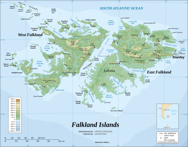
English: The Falkland Islands are an archipelago in the South Atlantic Ocean, located 300 miles off the coast of Argentina. They consist of two main islands, East Falkland and West Falkland, together with about 700 smaller islands. Stanley, on East Falkland, is the capital and largest city. The islands are a self-governing Overseas Territory of the United Kingdom.
Français : Carte topographique en anglais des Îles Malouines. Les Malouines forment un archipel dans l'Océan Atlantique Sud à 480 km des côtes argentines. Il est composé de deux îles principales, East Falkland et West Falkland, et de 700 autres îles et îlots. Stanley, sur East Falkland, est la capitale et la plus grande agglomération de l'archipel. Les Malouines sont un territoire autonome du Royaume-Uni.
Nederlands: Topografische kaart van de Falklandeilanden, een Brits overzees gebiedsdeel in de Zuidelijke Atlantische Oceaan. De archipel bestaat uit twee hoofdeilanden en ongeveer 700 kleinere op ongeveer 300 kilometer uit de kust van Argentinië. Stanley op het eiland 'East Falkland' is de hoofdstad en tergelijkertijd de meest bevolkte gemeente van het eilandengroep.De eilanden zijn een 'self-governing Overseas Territory' van het Verenigd Koninkrijk van Groot-Brittannië en Noord-Ierland.
Português: Mapa topográfico (em inglês) das Ilhas Malvinas, um arquipélago no sul do Oceano Atlântico, a 300 milhas da costa da Argentina. Consiste de duas ilhas, Soledad a leste e Gran Malvina, a oeste, junto com cerca de 700 outras ilhotas. A capital (e maior cidade) é Stanley. As Malvinas são um território autónomo do Reino Unido.
SVG genesis
InfoField
 
Սա վեկտոր գրաֆիկական պատկեր է ստեղծված է եղել Inkscape օգնությամբ: .
{| cellspacing="8" cellpadding="0" style="clear:both; width:100%; margin:0.5em auto; border:2px solid #88A; background-color:#F7F8FF;" lang="hy" dir="ltr"

|align="center"|Translate this file

|width="100%"|

Այս SVG ֆայլ օգտագործում է զետեղված տեքստ, որը կարելի է հեշտ թարգմանել ձեր լեզվի վրա using [toolforge:svgtranslate/File:Falkland_Islands_topographic_map-en.svglink this automated tool]: Իմացեք ավելին: You can also download it and translate it manually using a text editor.

|}
Թվական November 2007 using elements from the original version of April 2007
Աղբյուր Own work ;
Topographic map : NASA Shuttle Radar Topography Mission (SRTM3 v.2) (public domain) edited with dlgv32 Pro/Global Mapper and vectorized with Inkscape ; UTM projection ; WGS84 datum ; shaded relief (composite image of N-W, W and N lightning positions) ;
Approximate scale of topographic data and shore / lakes limits : 1:705,000 ; of the bathymetry : 1:3.720.000
Bathymetry : USGov public domain data provided by the Demis add-on for World Wind (see the approval e-mail) ;
Other references used for additional data :
* UK government map ;
* NASA World Wind ;
* CIA map available on the site of the University of Texas at Austin ;
* Microsoft Encarta atlas (1999 edition).
Note : The shaded relief is a raster image embedded in the SVG file which increases its size. If you want a lighter map for other purposes, delete the shaded relief image in your file.
Ստեղծել է
Eric Gaba (Sting - fr:Sting)
Իրավունքներ
(Նիշքի վերաօգտագործումը)
Attribution and Share-Alike required
Georeferencing Georeference the map in Wikimaps Warper If inappropriate please set warp_status = skip to hide.
Այլ մեկնակերպներ

Derivative works of this file:

[խմբագրել]


Արտոնագրում

Ես, այս աշխատանքի հեղինակային իրավունքների տերը, ներկա հրատարակում եմ սրա հետևյալ լիցենզիաների պայմաններով
GNU head Այս վավերագրման պատճենահանման, տարածման և/կամ ձևափոխման թույլտվություն կամ լիցենզիայի GNU FDL պայմաններով 1.2 մեկնակերպի կամ ավելի ուշ, հրատարակված Ազատ ծրագրային ապահովության հիմնադրամում, առանց անփոփոխելի հատվածների, առանց բնագիրների, որոնք տեղադրված են առաջին և վերջին շապիկներում: Լիցենզիայի պատճենը գտնվում է GNU Free Documentation License հատվածում:
w:en:Creative Commons
հղում համանման տարածում
Այս նիշքը հասանելի է Creative Commons Attribution-Share Alike 3.0 Unported արտոնագրի ներքո:
Դուք ազատ եք՝
  • կիսվել ստեղծագործությամբ – պատճենել, տարածել և փոխանցել այս աշխատանքը։
  • վերափոխել – ադապտացնել աշխատանքը
Պահպանելով հետևյալ պայմանները'
  • հղում – Դուք պետք է նշեք հեղինակի (իրավատիրոջ) հղումը:
  • համանման տարածում – Եթե դուք ձևափոխում եք, փոխակերպում, կամ այս աշխատանքի հիման վրա ստեղծում եք նոր աշխատանք, ապա ձեր ստեղծածը կարող է տարածվել միայն նույն կամ համարժեք թույլատրագրով։
Այս արտոնգրության հատկանիշը ավելացված է տվյալ նիշքին որպես GFDL արտոնագրի բարեփոխում:
w:en:Creative Commons
հղում համանման տարածում
This file is licensed under the Creative Commons Attribution-Share Alike 2.5 Generic, 2.0 Generic and 1.0 Generic license.
Դուք ազատ եք՝
  • կիսվել ստեղծագործությամբ – պատճենել, տարածել և փոխանցել այս աշխատանքը։
  • վերափոխել – ադապտացնել աշխատանքը
Պահպանելով հետևյալ պայմանները'
  • հղում – Դուք պետք է նշեք հեղինակի (իրավատիրոջ) հղումը:
  • համանման տարածում – Եթե դուք ձևափոխում եք, փոխակերպում, կամ այս աշխատանքի հիման վրա ստեղծում եք նոր աշխատանք, ապա ձեր ստեղծածը կարող է տարածվել միայն նույն կամ համարժեք թույլատրագրով։
Կարող եք ընտրել այս թույլատրագրերից ցանկացածը։

Captions

Add a one-line explanation of what this file represents

Նիշքի պատմություն

Մատնահարեք օրվան/ժամին՝ նիշքի այդ պահին տեսքը դիտելու համար։

(ամենաթարմ | ամենահին) Դիտել (ավելի թարմ 10 | ) (10 | 20 | 50 | 100 | 250 | 500)
Օր/ԺամՄանրապատկերՕբյեկտի չափըՄասնակիցՄեկնաբանություն
ընթացիկ02:51, 23 Օգոստոսի 202102:51, 23 Օգոստոսի 2021 տարբերակի մանրապատկերը2550 × 1990 (1,97 ՄԲ)Praça de MaioFile uploaded using svgtranslate tool (https://svgtranslate.toolforge.org/). Added translation for tr.
02:50, 23 Օգոստոսի 202102:50, 23 Օգոստոսի 2021 տարբերակի մանրապատկերը2550 × 1990 (1,97 ՄԲ)Praça de MaioFile uploaded using svgtranslate tool (https://svgtranslate.toolforge.org/). Added translation for tr.
11:54, 6 Ապրիլի 201711:54, 6 Ապրիլի 2017 տարբերակի մանրապատկերը2550 × 1990 (1,91 ՄԲ)RaviC+ New Haven Ferry
18:38, 19 Դեկտեմբերի 200818:38, 19 Դեկտեմբերի 2008 տարբերակի մանրապատկերը2550 × 1990 (1,93 ՄԲ)StingReverted to version as of 03:38, 14 November 2007: please upload the translated version under a specific name
18:26, 19 Դեկտեմբերի 200818:26, 19 Դեկտեմբերի 2008 տարբերակի մանրապատկերը2550 × 1990 (1,93 ՄԲ)Vitekthis is just croatian translation
03:38, 14 Նոյեմբերի 200703:38, 14 Նոյեմբերի 2007 տարբերակի մանրապատկերը2550 × 1990 (1,93 ՄԲ)StingNew version more accurate and with shaded relief
01:18, 16 Հունիսի 200701:18, 16 Հունիսի 2007 տարբերակի մանրապատկերը2550 × 1990 (1,03 ՄԲ)StingReverted to earlier revision
01:03, 16 Հունիսի 200701:03, 16 Հունիսի 2007 տարբերակի մանրապատկերը2550 × 1990 (2,14 ՄԲ)StingTrying to fix the bug on WP-en #8
00:40, 16 Հունիսի 200700:40, 16 Հունիսի 2007 տարբերակի մանրապատկերը2550 × 1990 (2,01 ՄԲ)StingTrying to fix the bug on WP-en #7 (really boring...)
00:29, 16 Հունիսի 200700:29, 16 Հունիսի 2007 տարբերակի մանրապատկերը2550 × 1990 (2,08 ՄԲ)StingTrying to fix the bug on WP-en #6 (OK, the problem comes from the shaded relief raster image)
(ամենաթարմ | ամենահին) Դիտել (ավելի թարմ 10 | ) (10 | 20 | 50 | 100 | 250 | 500)

Այս նիշքին օգտագործող էջեր չկան։

Նիշքի համընդհանուր օգտագործում

Հետևյալ այլ վիքիները օգտագործում են այս նիշքը՝

Տեսնել այս նիշքի ավելի համընդհանուր օգտագործումը:

Մետատվյալներ