
Պատկեր:Europe location SCO2.png

Նախադիտման չափ՝ 800 × 599 պիքսել։ Այլ թույլտվությաններ: 320 × 240 պիքսել | 640 × 479 պիքսել | 1024 × 767 պիքսել | 1280 × 959 պիքսել | 1594 × 1194 պիքսել.
Սկզբնական նիշք (1594 × 1194 փիքսել, նիշքի չափը՝ 558 ԿԲ, MIME-տեսակը՝ image/png)
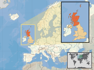
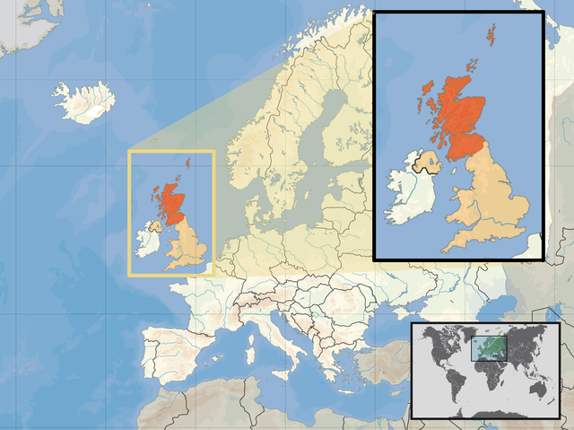
| Նկարագրում | Location of Scotland in the UK and Europe, on terrain map showing surface and underwater contour areas. | |||
| Թվական | ||||
| Աղբյուր | Derived from Wikimedia Commons image of original work forming part of the "Europe location" map series created by David Liuzzo: derived from Image:Europe_location_SCO.png. | |||
| Հեղինակ | uploaded by User:Kmusser (excerpt from User:David_Liuzzo) | |||
| Իրավունքներ (Նիշքի վերաօգտագործումը) |
|
|||
| Այլ մեկնակերպներ |
|


Նիշքի պատմություն
Մատնահարեք օրվան/ժամին՝ նիշքի այդ պահին տեսքը դիտելու համար։
| Օր/Ժամ | Մանրապատկեր | Օբյեկտի չափը | Մասնակից | Մեկնաբանություն | |
|---|---|---|---|---|---|
| ընթացիկ | 12:39, 10 Ապրիլի 2017 | | 1594 × 1194 (558 ԿԲ) | Von Sprat | Reverted to version as of 12:25, 27 May 2010 (UTC) |
| 12:39, 10 Ապրիլի 2017 |  | 1600 × 1200 (788 ԿԲ) | Von Sprat | greece/turkey border | |
| 12:25, 27 Մայիսի 2010 |  | 1594 × 1194 (558 ԿԲ) | Ras67 | cropped | |
| 17:31, 29 Սեպտեմբերի 2008 |  | 1600 × 1200 (767 ԿԲ) | Kmusser | re-cropped inset to include Shetlands | |
| 17:22, 29 Սեպտեմբերի 2008 |  | 1600 × 1200 (807 ԿԲ) | Kmusser | {{Information |Description= Location of Scotland in the UK and Europe, on terrain map showing surface and underwater contour areas. |Source=Derived from Wikimedia Commons image of original work forming part of the "Europe location" map series |
Նիշքի օգտագործում
Այս նիշքին օգտագործող էջեր չկան։
Նիշքի համընդհանուր օգտագործում
Հետևյալ այլ վիքիները օգտագործում են այս նիշքը՝
- Օգտագործումը als.wikipedia.org կայքում
- Օգտագործումը an.wikipedia.org կայքում
- Օգտագործումը az.wiktionary.org կայքում
- Օգտագործումը ca.wikipedia.org կայքում
- Օգտագործումը da.wikipedia.org կայքում
- Օգտագործումը en.wikipedia.org կայքում
- Օգտագործումը es.wikipedia.org կայքում
- Օգտագործումը eu.wiktionary.org կայքում
- Օգտագործումը ext.wikipedia.org կայքում
- Օգտագործումը fiu-vro.wikipedia.org կայքում
- Օգտագործումը fr.wikinews.org կայքում
- Օգտագործումը gag.wikipedia.org կայքում
- Օգտագործումը gl.wikipedia.org կայքում
- Օգտագործումը hr.wikipedia.org կայքում
- Օգտագործումը hr.wikiquote.org կայքում
- Օգտագործումը kn.wikipedia.org կայքում
- Օգտագործումը krc.wikipedia.org կայքում
- Օգտագործումը ml.wikipedia.org կայքում
- Օգտագործումը mnw.wikipedia.org կայքում
- Օգտագործումը mr.wikipedia.org կայքում
- Օգտագործումը my.wikipedia.org կայքում
- Օգտագործումը nov.wikipedia.org կայքում
- Օգտագործումը no.wikipedia.org կայքում
- Օգտագործումը pl.wikipedia.org կայքում
- Օգտագործումը pl.wikivoyage.org կայքում
- Օգտագործումը pl.wiktionary.org կայքում
- Օգտագործումը su.wikipedia.org կայքում
- Օգտագործումը sv.wikivoyage.org կայքում
- Օգտագործումը te.wikipedia.org կայքում
- Օգտագործումը tr.wikipedia.org կայքում
- Օգտագործումը ug.wikipedia.org կայքում
- Օգտագործումը vls.wikipedia.org կայքում
- Օգտագործումը yo.wikipedia.org կայքում