
Պատկեր:Europe 1914 Shepherd.jpg
Սկզբնական նիշք (1789 × 1465 փիքսել, նիշքի չափը՝ 3,78 ՄԲ, MIME-տեսակը՝ image/jpeg)
Ամփոփում
| Նկարագրում |
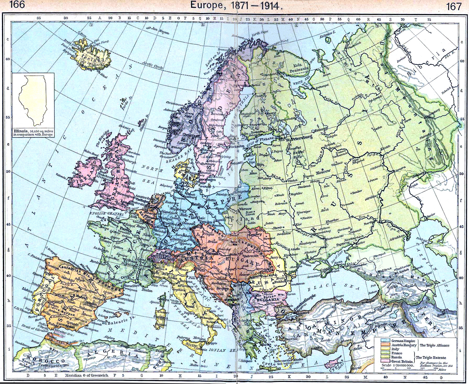
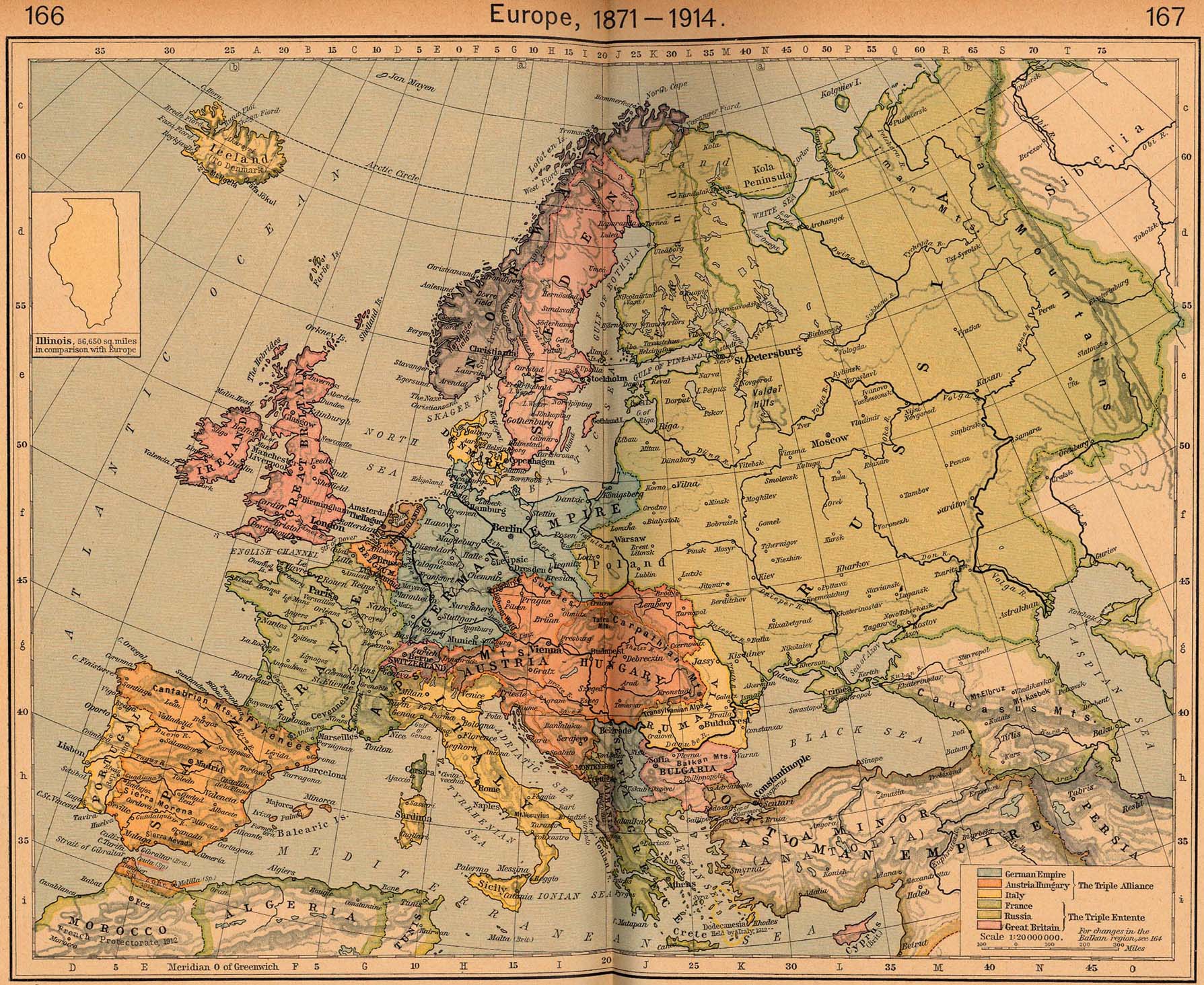
English: Map of Europe in 1914 |
||||||||||||||||||||||
| Թվական | |||||||||||||||||||||||
| Աղբյուր | http://www.lib.utexas.edu/maps/historical/shepherd/europe_1871_1914.jpg | ||||||||||||||||||||||
| Հեղինակ |
|
||||||||||||||||||||||
This is from the 1926 edition of the "Historical Atlas" by William R. Shepherd published by the Henry Holt and Company, New York. It may have been first published earlier in previous editions. The image is from the University of Texas Perry-Castañeda Library Map Collection.
Արտոնագրում
|
This work is in the public domain in its country of origin and other countries and areas where the copyright term is the author's life plus 70 years or fewer.
| |
| This file has been identified as being free of known restrictions under copyright law, including all related and neighboring rights. | |
_en.png)
.png)
.jpg)
Նիշքի պատմություն
Մատնահարեք օրվան/ժամին՝ նիշքի այդ պահին տեսքը դիտելու համար։
| Օր/Ժամ | Մանրապատկեր | Օբյեկտի չափը | Մասնակից | Մեկնաբանություն | |
|---|---|---|---|---|---|
| ընթացիկ | 12:15, 20 Սեպտեմբերի 2022 | | 1789 × 1465 (3,78 ՄԲ) | Рагин1987 | Small correction |
| 09:17, 21 Մարտի 2012 |  | 1789 × 1465 (2,73 ՄԲ) | Phoenix7777 | Reduced creases | |
| 13:55, 20 Մարտի 2012 |  | 1789 × 1465 (2,85 ՄԲ) | 1Veertje | more exposure on the fold | |
| 00:48, 23 փետրվարի 2011 |  | 1789 × 1465 (2,84 ՄԲ) | Pearts | sides lined up, page bends made a little less visible, vibrance reduced a little | |
| 16:26, 3 Հոկտեմբերի 2010 |  | 1789 × 1465 (1,39 ՄԲ) | PawełMM | flattened & whitened | |
| 14:49, 6 Հուլիսի 2010 |  | 1789 × 1465 (623 ԿԲ) | Yebellz | Whitened Version | |
| 14:41, 6 Հուլիսի 2010 |  | 1789 × 1465 (604 ԿԲ) | Yebellz | {{Information |Description={{en|1=Map of Europe in 1914}} |Source=http://www.lib.utexas.edu/maps/historical/shepherd/europe_1871_1914.jpg |Author=William R. Shepherd |Date=1926 |Permission= |other_versions= }} This is from the 1926 edition of the "Histori |
Նիշքի օգտագործում
Հետևյալ էջը հղվում է այս նիշքին՝
Նիշքի համընդհանուր օգտագործում
Հետևյալ այլ վիքիները օգտագործում են այս նիշքը՝
- Օգտագործումը en.wikipedia.org կայքում
- Օգտագործումը hu.wikipedia.org կայքում
- Օգտագործումը nl.wikipedia.org կայքում
- Օգտագործումը pl.wikipedia.org կայքում
- Օգտագործումը pt.wikipedia.org կայքում
- Օգտագործումը ru.wikipedia.org կայքում