
Պատկեր:Cyclades-Satellite.png

Նախադիտման չափ՝ 661 × 600 պիքսել։ Այլ թույլտվությաններ: 265 × 240 պիքսել | 529 × 480 պիքսել | 846 × 768 պիքսել | 1129 × 1024 պիքսել | 1965 × 1783 պիքսել.
Սկզբնական նիշք (1965 × 1783 փիքսել, նիշքի չափը՝ 1,83 ՄԲ, MIME-տեսակը՝ image/png)
Ամփոփում
| Նկարագրում | |
| Թվական | 25 Հուլիս 2007 (original upload date) |
| Աղբյուր |
|
| Հեղինակ | Henryhartley at en.wikipedia |
| Իրավունքներ (Նիշքի վերաօգտագործումը) |
Since the satellite image is originally a NASA image, I believe this is a legal use. |
Արտոնագրում
Henryhartley at the English Wikipedia, սույն աշխատանքի հեղինակային իրավունքների տերը, այսուհետ այն հրատարակում է հետևյալ արտոնագրի պայմաններով՝

|
Այս վավերագրման պատճենահանման, տարածման և/կամ ձևափոխման թույլտվություն կամ լիցենզիայի GNU FDL պայմաններով 1.2 մեկնակերպի կամ ավելի ուշ, հրատարակված Ազատ ծրագրային ապահովության հիմնադրամում, առանց անփոփոխելի հատվածների, առանց բնագիրների, որոնք տեղադրված են առաջին և վերջին շապիկներում: Լիցենզիայի պատճենը գտնվում է GNU Free Documentation License հատվածում: |
Original upload log
The original description page was here. All following user names refer to en.wikipedia.
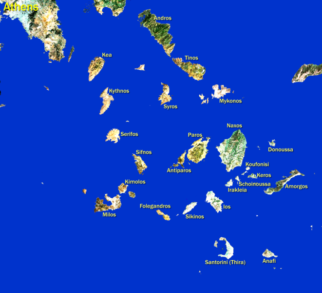
- 2007-07-25 18:41 Henryhartley 1965×1783× (1922903 bytes) Satellite image as used by Google Maps but modified by removing sea, brightening land, and adding island names. Since the satellite image is originally a NASA image, I believe this is a legal use. All modifications are by me.
Նիշքի պատմություն
Մատնահարեք օրվան/ժամին՝ նիշքի այդ պահին տեսքը դիտելու համար։
| Օր/Ժամ | Մանրապատկեր | Օբյեկտի չափը | Մասնակից | Մեկնաբանություն | |
|---|---|---|---|---|---|
| ընթացիկ | 01:12, 11 Ապրիլի 2012 | | 1965 × 1783 (1,83 ՄԲ) | OgreBot | (BOT): Uploading old version of file from en.wikipedia; originally uploaded on 2007-07-25 18:41:32 by Henryhartley |
| 21:35, 30 Հունիսի 2009 |  | 661 × 600 (163 ԿԲ) | Dorieo | {{Information |Description={{en|Satellite image as used by Google Maps but modified by removing sea, brightening land, and adding island names. Since the satellite image is originally a NASA image, I believe this is a legal use. All modifications are by m |
Նիշքի օգտագործում
Հետևյալ էջը հղվում է այս նիշքին՝
Նիշքի համընդհանուր օգտագործում
Հետևյալ այլ վիքիները օգտագործում են այս նիշքը՝
- Օգտագործումը af.wikipedia.org կայքում
- Օգտագործումը azb.wikipedia.org կայքում
- Օգտագործումը el.wikipedia.org կայքում
- Օգտագործումը en.wikipedia.org կայքում
- Օգտագործումը es.wikipedia.org կայքում
- Օգտագործումը fr.wikipedia.org կայքում
- Օգտագործումը gl.wikipedia.org կայքում
- Օգտագործումը mk.wikipedia.org կայքում
- Օգտագործումը simple.wikipedia.org կայքում
- Օգտագործումը tr.wikipedia.org կայքում
- Santorini
- Nakşa
- Yamurgi
- Sire
- Delos
- Niyoz
- Mikonos
- Yunanistan'a birinci Pers saldırısı
- Anafiye
- Berre
- Değirmenlik, Yunanistan
- Mürted (ada)
- Termiye
- İstendil
- Gümüş (ada)
- Koyunluca
- Yavuzca
- Andiberre
- Bolukendire
- Eskinos
- Bibercik
- Küçük Değirmenlik
- Papazlık Adası
- Hacılar, Yunanistan
- Örenli, Yunanistan
- Yassıca, Yunanistan
- Eskino
- Serbarlı Adası
- Polino Adası
- Despotiko
- Karo Adası
- Kardivinis Adası
- Serfo Adası
- Sığırcıklar Adası
- Şablon:Kiklad Adaları
- Küçük Kikladlar
- Salyagos
- Andire