
Պատկեր:Cook new zealand.jpg
Սկզբնական նիշք (861 × 1024 փիքսել, նիշքի չափը՝ 307 ԿԲ, MIME-տեսակը՝ image/jpeg)
Ամփոփում
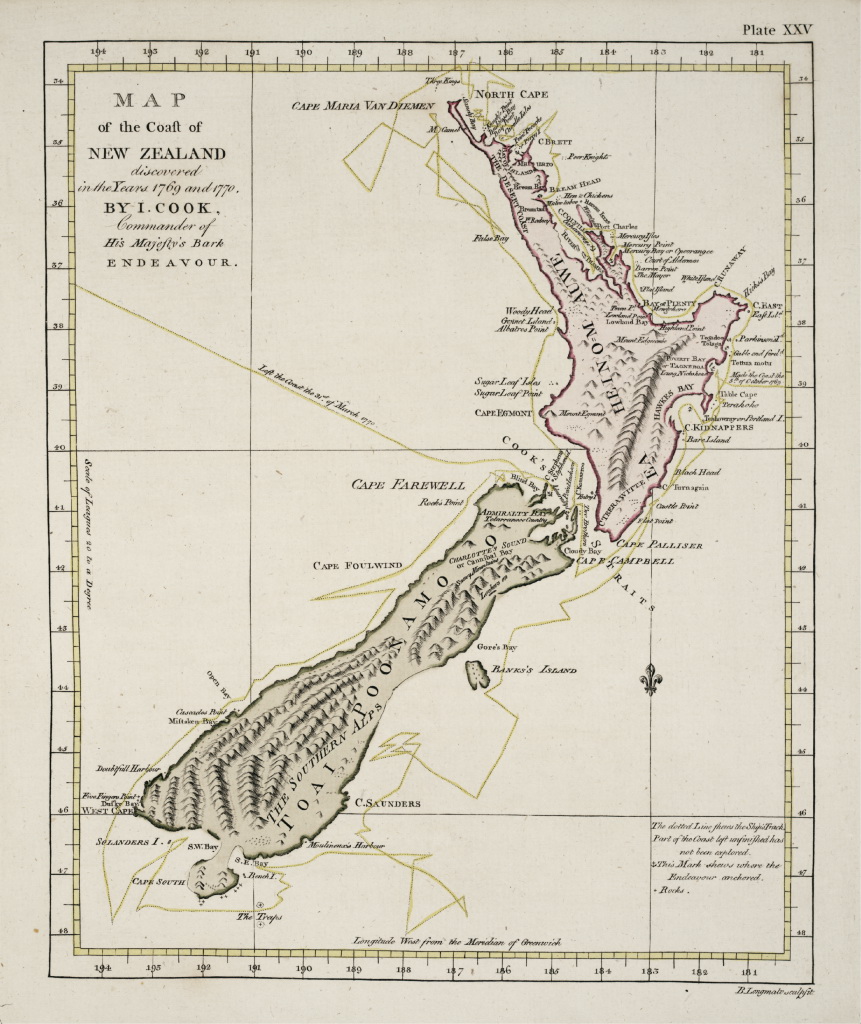
| Նկարագրում | First nearly complete map of New Zealand. From the outset, the country has been in the forefront in instituting social welfare leg |
| Աղբյուր | International Cartographic Association |
| Հեղինակ | drawn by James Cook |
| Այլ մեկնակերպներ | south-eastern part of the map at Image:Cook New Zealand South Cape.jpg islation. |
Արտոնագրում
|
Այս պատկերում գտնվող երկչափ ստեղծագործությունը հանրության սեփականություն է ամբողջ աշխարհում հեղինակի մահվան ժամանակի, կամ առաջի հրատարակման պատճառով:
Այսպիսով, տվյալ վերարտադրումը նույնպես հանրության սեփականություն է: Դա վերաբերվում է ԱՄՆ-ում, Գերմանիայում և ուրիշ բազմաթիվ պետություններում ստեղծված երկերին: {{PD-Art}} template without license parameter: please specify why the underlying work is public domain in both the source country and the United States
(Usage: {{PD-Art|1=|deathyear=''year of author's death''|country=''source country''}}, where parameter #1 can be PD-old-auto, PD-old-auto-expired, PD-old-auto-1996, PD-old-100 or similar. See Commons:Multi-license copyright tags for more information.) | ||||
Նիշքի պատմություն
Մատնահարեք օրվան/ժամին՝ նիշքի այդ պահին տեսքը դիտելու համար։
| Օր/Ժամ | Մանրապատկեր | Օբյեկտի չափը | Մասնակից | Մեկնաբանություն | |
|---|---|---|---|---|---|
| ընթացիկ | 16:00, 21 Հուլիսի 2022 | | 861 × 1024 (307 ԿԲ) | Serhio Magpie | Higher resolution |
| 09:18, 1 Ապրիլի 2007 |  | 499 × 601 (67 ԿԲ) | Ibn Battuta | sheared to reestablish proportions and orthogonal angels | |
| 23:12, 29 Նոյեմբերի 2006 |  | 500 × 603 (46 ԿԲ) | Electionworld | First nearly complete map of New Zealand, drawn by James Cook. == Licensing == {{PD-art}} Category:Old maps of New Zealand |
Նիշքի օգտագործում
Հետևյալ 2 էջերը հղվում են այս նիշքին՝
Նիշքի համընդհանուր օգտագործում
Հետևյալ այլ վիքիները օգտագործում են այս նիշքը՝
- Օգտագործումը af.wikipedia.org կայքում
- Օգտագործումը ba.wikipedia.org կայքում
- Օգտագործումը bg.wikipedia.org կայքում
- Օգտագործումը ca.wikipedia.org կայքում
- Օգտագործումը de.wikipedia.org կայքում
- Օգտագործումը en.wikipedia.org կայքում
- Օգտագործումը en.wikibooks.org կայքում
- Օգտագործումը eu.wikipedia.org կայքում
- Օգտագործումը fi.wikipedia.org կայքում
- Օգտագործումը fr.wikipedia.org կայքում
- Օգտագործումը he.wikipedia.org կայքում
- Օգտագործումը hu.wikipedia.org կայքում
- Օգտագործումը ia.wikipedia.org կայքում
- Օգտագործումը it.wikipedia.org կայքում
- Օգտագործումը ko.wikipedia.org կայքում
- Օգտագործումը lt.wikipedia.org կայքում
- Օգտագործումը lv.wikipedia.org կայքում
- Օգտագործումը mk.wikipedia.org կայքում
- Օգտագործումը no.wikipedia.org կայքում
- Օգտագործումը os.wikipedia.org կայքում
- Օգտագործումը pl.wikipedia.org կայքում
- Օգտագործումը pt.wikipedia.org կայքում
- Օգտագործումը pt.wikibooks.org կայքում
- Օգտագործումը ru.wikipedia.org կայքում
- Օգտագործումը sh.wikipedia.org կայքում
- Օգտագործումը sv.wikipedia.org կայքում
- Օգտագործումը uk.wikipedia.org կայքում
- Օգտագործումը uz.wikipedia.org կայքում
- Օգտագործումը vi.wikipedia.org կայքում
- Օգտագործումը zh.wikipedia.org կայքում