
Պատկեր:Cape Kazantip, Kerch Peninsula, Southern Sea of Azov, Ukraine.JPG

Նախադիտման չափ՝ 800 × 533 պիքսել։ Այլ թույլտվությաններ: 320 × 213 պիքսել | 640 × 426 պիքսել | 1024 × 682 պիքսել | 1280 × 852 պիքսել | 2560 × 1705 պիքսել | 6048 × 4028 պիքսել.
Սկզբնական նիշք (6048 × 4028 փիքսել, նիշքի չափը՝ 3,96 ՄԲ, MIME-տեսակը՝ image/jpeg)
Ամփոփում
| Նկարագրում |
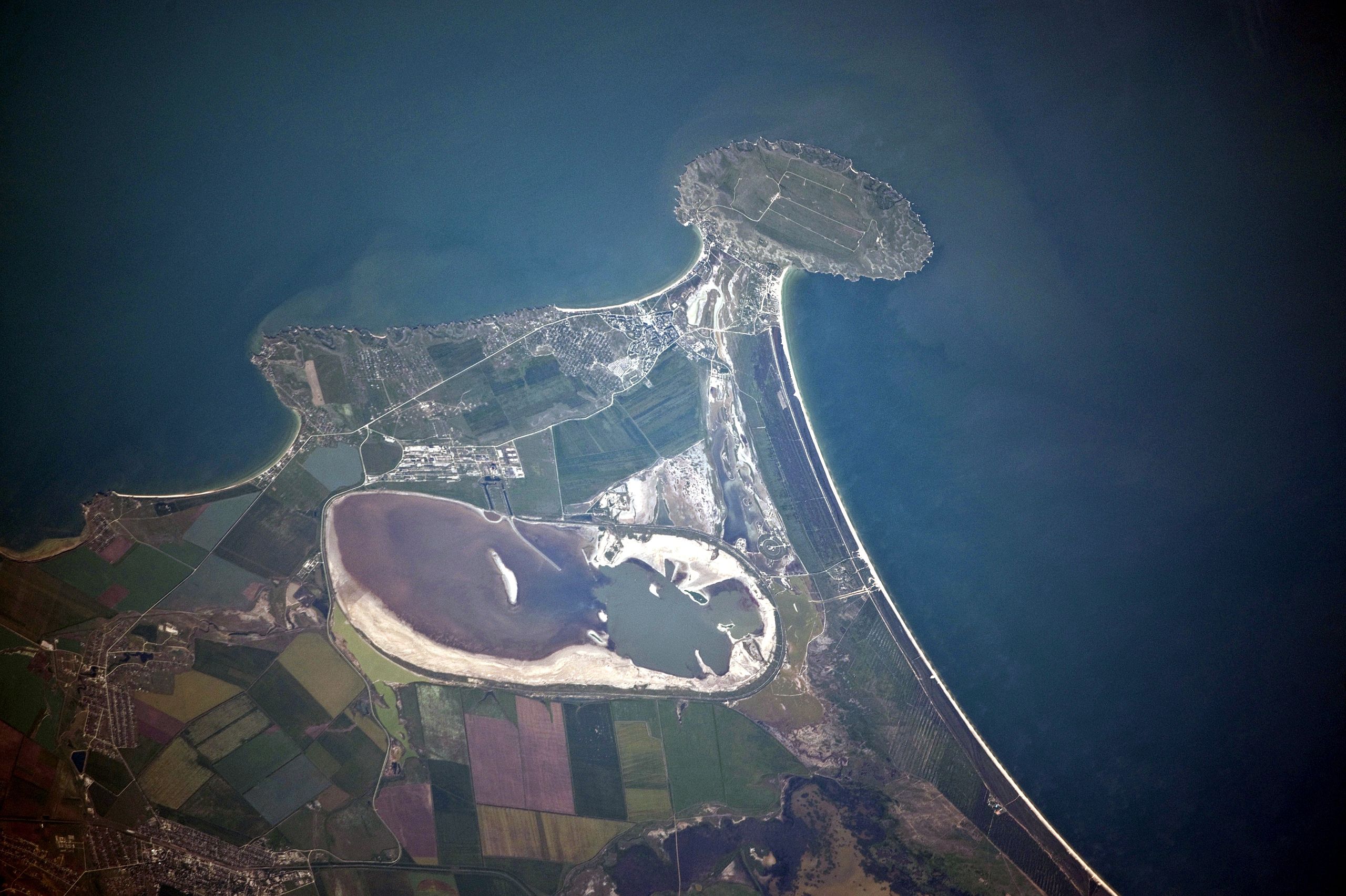
English: Cape Kazantip is a prominent headland on the Kerch Peninsula, which defines the southern shore of the Sea of Azov and the east extension of the Crimean Peninsula. During the Second World War, German and Soviet forces fought on the Kerch Peninsula, with the line of battle impinging on areas shown at the bottom of the image. The distance from the tip of the Cape to the largest local city, Lenine (population ~70,000, image lower left) is only 20 kilometres.
Français : A l'est de la péninsule de Crimée, Cap Kazantip est un promontoire sur la péninsule de Kertch, sur la rive sud de la mer d'Azov. Pendant la Seconde Guerre mondiale, les forces allemandes et soviétiques se sont battus sur la péninsule de Kertch. De la pointe du Cap à plus grande ville locale, Lenine (population ~ 70 000), il y a 20 kilomètres. Une centrale nucléaire en construction a été suspendue en 1989, suite à la chute du bloc soviétique. |
| Թվական | |
| Աղբյուր | NASA Earth Observatory |
| Հեղինակ | ISS Expedition 23 crew |
| Տեսախցիկի տեղագրություն | | Այս և ուրիշ պատկերներ իրենց տեղագրությամբ OpenStreetMap |
|---|
Այս պատկերը կամ տեսագրությունը մտցրած են одного из исследовательских центров Национального управления США по аэронавтике и исследованию космического пространства (NASA)под идентификатором (Photo ID): ISS023-E-56842. Эта пометка не указывает на правовой статус данной работы. Пометка о правовом статусе по-прежнему необходима. См. подробнее правила лицензирования Викисклада. Other languages:
|
This detailed astronaut photograph was taken from the International Space Station (ISS) when it was located 400 kilometres to the north-east, but due to the long (800 mm) lens used, the photo includes detailed field patterns and city blocks. Green and brown fields show intensive agricultural activity in the area, and salt ponds are visible at the west end of the shallow Lake Aktashskoye at image centre.
Արտոնագրում
| Այս նիշքը հանրության սեփականության է պատկանում, քանզի այն ստեղծվել է ՆԱՍԱ-ն։ ՆԱՍԱ-ի հեղինակային իրավունքների մասին քաղաքականությունը նշում է, որ «ՆԱՍԱ-ի նյութերը հեղինակային իրավունքներով պաշտպանված չեն, միթե այդպես նշված լինի»։ (Տե՛ս Template:PD-USGov, ՆԱՍԱ-ի հեղինակային իրավունքների քաղաքականության մասին էջը կամ ՋեյՓիԷլի պատկերների օգտագործման մասին քաղաքականությունը)։ | ||
 |
Զգուշացումներ՝:
|
| Annotations | This image is annotated: View the annotations at Commons |
Նիշքի պատմություն
Մատնահարեք օրվան/ժամին՝ նիշքի այդ պահին տեսքը դիտելու համար։
| Օր/Ժամ | Մանրապատկեր | Օբյեկտի չափը | Մասնակից | Մեկնաբանություն | |
|---|---|---|---|---|---|
| ընթացիկ | 12:42, 20 Հուլիսի 2010 | | 6048 × 4028 (3,96 ՄԲ) | Originalwana | {{Information |Description={{en|1=Cape Kazantip is a prominent headland on the Kerch Peninsula, which defines the southern shore of the Sea of Azov and the east extension of the Crimean Peninsula. During the [[World W |
Նիշքի օգտագործում
Հետևյալ էջը հղվում է այս նիշքին՝
Նիշքի համընդհանուր օգտագործում
Հետևյալ այլ վիքիները օգտագործում են այս նիշքը՝
- Օգտագործումը arz.wikipedia.org կայքում
- Օգտագործումը az.wikipedia.org կայքում
- Օգտագործումը be.wikipedia.org կայքում
- Օգտագործումը ceb.wikipedia.org կայքում
- Օգտագործումը crh.wikipedia.org կայքում
- Օգտագործումը de.wikipedia.org կայքում
- Օգտագործումը en.wikipedia.org կայքում
- Օգտագործումը eo.wikipedia.org կայքում
- Օգտագործումը es.wikipedia.org կայքում
- Օգտագործումը fa.wikipedia.org կայքում
- Օգտագործումը fi.wikipedia.org կայքում
- Օգտագործումը fr.wikipedia.org կայքում
- Օգտագործումը hr.wikipedia.org կայքում
- Օգտագործումը ka.wikipedia.org կայքում
- Օգտագործումը nn.wikipedia.org կայքում
- Օգտագործումը pl.wikipedia.org կայքում
- Օգտագործումը ro.wikipedia.org կայքում
- Օգտագործումը ru.wikipedia.org կայքում
- Օգտագործումը ru.wikivoyage.org կայքում
- Օգտագործումը uk.wikipedia.org կայքում
- Օգտագործումը www.wikidata.org կայքում