
Պատկեր:Bush Barrow - geograph.org.uk - 1622275.jpg
Bush_Barrow_-_geograph.org.uk_-_1622275.jpg (640 × 480 փիքսել, նիշքի չափը՝ 76 ԿԲ, MIME-տեսակը՝ image/jpeg)
Ամփոփում
| Նկարագրում |
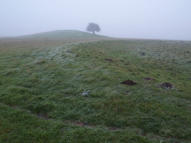
English: Bush Barrow "In the 1720s William Stukeley had called it the bush barrow after trees planted on the top (though the county people knew it as the green barrow)" http://www.britarch.ac.uk/ba/ba104/feat1.shtml .
"This very large bowl barrow in the Normanton Down barrow group, just south of Stonehenge, measures over 40m in diameter and stands today 3m high. It was excavated in 1808 by William Cunnington and Sir Richard Colt Hoare. The primary burial was of a tall, stout, adult man, buried lying on his back. The grave goods placed with him show that this was a princely burial from about 1900 -1700 B.C. It is Britain's richest and most important Bronze Age burial" http://www.wiltshireheritage.org.uk/galleries/index.php?Action=3&obID=89&prevID=9 . In the foreground is a round barrow. Together they form part of the Normanton Down Barrows. The first link gives much detail about the excavation of Bush Barrow and the site as a whole. |
| Թվական | |
| Աղբյուր | From geograph.org.uk |
| Հեղինակ | Derek Harper |
| Հղում (required by the license) | Derek Harper / Bush Barrow / |
| Տեսախցիկի տեղագրություն | | Այս և ուրիշ պատկերներ իրենց տեղագրությամբ OpenStreetMap |
|---|
_heading:112.00&language=hy)
| Օբյեկտի տեղագրություն | | Այս և ուրիշ պատկերներ իրենց տեղագրությամբ OpenStreetMap |
|---|
_heading:112.00&language=hy)
Արտոնագրում

|
This image was taken from the Geograph project collection. See this photograph's page on the Geograph website for the photographer's contact details. The copyright on this image is owned by Derek Harper and is licensed for reuse under the Creative Commons Attribution-ShareAlike 2.0 license.
|
- Դուք ազատ եք՝
- կիսվել ստեղծագործությամբ – պատճենել, տարածել և փոխանցել այս աշխատանքը։
- վերափոխել – ադապտացնել աշխատանքը
- Պահպանելով հետևյալ պայմանները'
- հղում – Դուք պետք է նշեք հեղինակի (իրավատիրոջ) հղումը:
- համանման տարածում – Եթե դուք ձևափոխում եք, փոխակերպում, կամ այս աշխատանքի հիման վրա ստեղծում եք նոր աշխատանք, ապա ձեր ստեղծածը կարող է տարածվել միայն նույն կամ համարժեք թույլատրագրով։
Նիշքի պատմություն
Մատնահարեք օրվան/ժամին՝ նիշքի այդ պահին տեսքը դիտելու համար։
| Օր/Ժամ | Մանրապատկեր | Օբյեկտի չափը | Մասնակից | Մեկնաբանություն | |
|---|---|---|---|---|---|
| ընթացիկ | 12:33, 4 Մարտի 2011 | | 640 × 480 (76 ԿԲ) | GeographBot | == {{int:filedesc}} == {{Information |description={{en|1=Bush Barrow "In the 1720s William Stukeley had called it the bush barrow after trees planted on the top (though the county people knew it as the green barrow)" http://www.britarch.ac.uk/ |
Նիշքի օգտագործում
Հետևյալ էջը հղվում է այս նիշքին՝
Նիշքի համընդհանուր օգտագործում
Հետևյալ այլ վիքիները օգտագործում են այս նիշքը՝
- Օգտագործումը de.wikipedia.org կայքում
- Օգտագործումը en.wikipedia.org կայքում
- Օգտագործումը it.wikipedia.org կայքում
- Օգտագործումը nl.wikipedia.org կայքում
- Օգտագործումը www.wikidata.org կայքում