
Պատկեր:Bournemouth, the Waterfront building - geograph.org.uk - 670298.jpg
Ավելի բարձր կետաչափով տարբերակ չկա։
Bournemouth,_the_Waterfront_building_-_geograph.org.uk_-_670298.jpg (640 × 480 փիքսել, նիշքի չափը՝ 72 ԿԲ, MIME-տեսակը՝ image/jpeg)
Ամփոփում
| Նկարագրում |
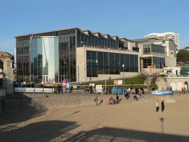
English: Bournemouth: the Waterfront building Erected in the late 1990s, this is one of Bournemouth's most controversial buildings ever. It contains a pub (whose balcony can be seen here), Chinese restaurant and Kentucky Fried Chicken, all surrounding the central IMAX theatre - for more discussion on which, see 641820.
As of March 2013 this building was demolished http://www.bournemouthecho.co.uk/news/10262506.Imax_watch__onlookers_gathering_to_take_pictures_of_demolition_process/ |
| Թվական | |
| Աղբյուր | From geograph.org.uk |
| Հեղինակ | Chris Downer |
| Հղում (required by the license) | Chris Downer / Bournemouth: the Waterfront building / |
| Տեսախցիկի տեղագրություն | | Այս և ուրիշ պատկերներ իրենց տեղագրությամբ OpenStreetMap |
|---|
_heading:22.00&language=hy)
| Օբյեկտի տեղագրություն | | Այս և ուրիշ պատկերներ իրենց տեղագրությամբ OpenStreetMap |
|---|
_heading:22.00&language=hy)
Արտոնագրում

|
This image was taken from the Geograph project collection. See this photograph's page on the Geograph website for the photographer's contact details. The copyright on this image is owned by Chris Downer and is licensed for reuse under the Creative Commons Attribution-ShareAlike 2.0 license.
|
This file is licensed under the Creative Commons Attribution-Share Alike 2.0 Generic license.
Հղում: Chris Downer
- Դուք ազատ եք՝
- կիսվել ստեղծագործությամբ – պատճենել, տարածել և փոխանցել այս աշխատանքը։
- վերափոխել – ադապտացնել աշխատանքը
- Պահպանելով հետևյալ պայմանները'
- հղում – Դուք պետք է նշեք հեղինակի (իրավատիրոջ) հղումը:
- համանման տարածում – Եթե դուք ձևափոխում եք, փոխակերպում, կամ այս աշխատանքի հիման վրա ստեղծում եք նոր աշխատանք, ապա ձեր ստեղծածը կարող է տարածվել միայն նույն կամ համարժեք թույլատրագրով։
Նիշքի պատմություն
Մատնահարեք օրվան/ժամին՝ նիշքի այդ պահին տեսքը դիտելու համար։
| Օր/Ժամ | Մանրապատկեր | Օբյեկտի չափը | Մասնակից | Մեկնաբանություն | |
|---|---|---|---|---|---|
| ընթացիկ | 21:32, 7 փետրվարի 2011 | | 640 × 480 (72 ԿԲ) | GeographBot | == {{int:filedesc}} == {{Information |description={{en|1=Bournemouth: the Waterfront building Erected in the late 1990s, this is one of Bournemouth's most controversial buildings ever. It contains a pub (whose balcony can be seen here), Chinese restaurant |
Նիշքի օգտագործում
Հետևյալ էջը հղվում է այս նիշքին՝
Նիշքի համընդհանուր օգտագործում
Հետևյալ այլ վիքիները օգտագործում են այս նիշքը՝
- Օգտագործումը ar.wikipedia.org կայքում
- Օգտագործումը azb.wikipedia.org կայքում
- Օգտագործումը en.wikipedia.org կայքում