
Պատկեր:BlankMapTurkishProvincesRegions.svg

Սկզբնական նիշք (SVG-նիշք, անվանապես 1052 × 744 փիքսել, նիշքի չափը՝ 189 ԿԲ)
Ամփոփում
| Նկարագրում |
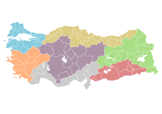
Map of Republic of Turkey's provinces, with regions separated by color. Each entity holds name of province and ISO 3166 code information. The original map is available as Image:BlankMapTurkeyProvinces.png. The author gave the following information: Description=Blank map of Republic of Turkey's provinces. The regions are carefully separated on per pixel basis and ready for filling in with a paint tool. Couleurs (légende)
Source=Self drawn from scratch, based on data from official Turkish motorway network map Date=December 21, 2006 Author=Atilim Gunes Baydin Permission=I grant permission for anyone to use this under the terms of GFDL license, see below |
| Թվական | 21 Դեկտեմբեր 2006 (original upload date) |
| Աղբյուր | Originally from commons.wikipedia; description page is/was here. |
| Հեղինակ |
Modifications made by user User:Hk_kng at commons.wikipedia Original uploader was AtilimGunesBaydin at commons.wikipedia |
| Իրավունքներ (Նիշքի վերաօգտագործումը) |
Released under the GNU Free Documentation License; Licensed under the GFDL by the author. |
Original upload log
(All user names refer to commons.wikipedia)
- 2007-02-18 22:14 AtilimGunesBaydin 1024×500×8 (23317 bytes) Removed Samothraki, which was accidentally included. I'm sorry for the mistake.
- 2006-12-22 16:46 AtilimGunesBaydin 1024×500×8 (23347 bytes) Slight resize.
- 2006-12-21 21:51 AtilimGunesBaydin 1024×499×8 (23338 bytes) {{Information |Description=Blank map of [[:en:Turkey|Republic of Turkey]]'s provinces |Source=Drawn from scratch on based on data from [http://www.kgm.gov.tr/images/trkh-yeni1.jpg official Turkish motorway network map] |Date=December 21, 2006 |Author=[[:e
Արտոնագրում

|
Այս վավերագրման պատճենահանման, տարածման և/կամ ձևափոխման թույլտվություն կամ լիցենզիայի GNU FDL պայմաններով 1.2 մեկնակերպի կամ ավելի ուշ, հրատարակված Ազատ ծրագրային ապահովության հիմնադրամում, առանց անփոփոխելի հատվածների, առանց բնագիրների, որոնք տեղադրված են առաջին և վերջին շապիկներում: Լիցենզիայի պատճենը գտնվում է GNU Free Documentation License հատվածում: |
| Այս նիշքը հասանելի է Creative Commons Attribution-Share Alike 3.0 Unported արտոնագրի ներքո: | ||
| ||
| Այս արտոնգրության հատկանիշը ավելացված է տվյալ նիշքին որպես GFDL արտոնագրի բարեփոխում: |
Նիշքի պատմություն
Մատնահարեք օրվան/ժամին՝ նիշքի այդ պահին տեսքը դիտելու համար։
| Օր/Ժամ | Մանրապատկեր | Օբյեկտի չափը | Մասնակից | Մեկնաբանություն | |
|---|---|---|---|---|---|
| ընթացիկ | 02:21, 9 Ապրիլի 2007 | | 1052 × 744 (189 ԿԲ) | Hk kng | {{Information |Description=''no original description'' |Source=Originally from [http://en.wikipedia.org en.wikipedia]; description page is/was [http://en.wikipedia.org/w/index.php?title=Image%3ABlankMapTurkeyProvinces.png here]. |Date= (original upload da |
Նիշքի օգտագործում
Հետևյալ 99 էջերը հղվում են այս նիշքին՝
- Ադանայի մարզ
- Ադըյամանի մարզ
- Աղրըի մարզ
- Ամասիայի մարզ
- Այդընի մարզ
- Այդընջըք (Մերսին)
- Անթալիայի մարզ
- Անկարայի մարզ
- Արդահանի մարզ
- Արդվինի մարզ
- Արևելյան Անատոլիա
- Աքսարայի մարզ
- Աֆյոնքարահիսարի մարզ
- Բաթմանի մարզ
- Բալըքեսիրի մարզ
- Բայբուրթի մարզ
- Բարթընի մարզ
- Բիթլիսի մարզ
- Բիլեջիքի մարզ
- Բինգյոլի մարզ
- Բոլուի մարզ
- Բոր (Նիղդե)
- Բուրդուրի մարզ
- Բուրսայի մարզ
- Գազիանթեփի մարզ
- Գիրեսունի մարզ
- Գյումյուշհանեի մարզ
- Դենիզլիի մարզ
- Դիարբեքիրի մարզ
- Դյուզջեի մարզ
- Եգեյան տարածաշրջան
- Զոնգուլդաքի մարզ
- Էդիրնեի մարզ
- Էլազըղի մարզ
- Էսքիշեհիրի մարզ
- Էրզինջանի մարզ
- Էրզրումի մարզ
- Ըսփարթայի մարզ
- Թեքիրդաղի մարզ
- Թունջելիի մարզ
- Թուրքիայի աշխարհագրական շրջաններ
- Թուրքիայի շրջաններ
- Թուրքիայի վարչական բաժանում
- Թուրքիայի տարածաշրջաններ
- Թոքաթի մարզ
- Իգդիրի մարզ
- Իզմիրի մարզ
- Կայսերիի մարզ
- Կարսի մարզ (Թուրքիա)
- Կենտրոնական Անատոլիա
- Հաթայի մարզ
- Հալեպի վիլայեթ
- Հարավարևելյան Անատոլիա
- Հաքյարիի մարզ
- Մալաթիայի մարզ
- Մանիսայի մարզ
- Մարդինի մարզ
- Մարմարածովյան տարածաշրջան
- Մերսինի մարզ
- Միջերկրածովյան տարածաշրջան
- Մուղլայի մարզ
- Մուշի նահանգ
- Յաթաղան (Մուղլա)
- Յալովայի մարզ
- Յոզգաթի մարզ
- Նիղդեի մարզ
- Նևշեհիրի մարզ
- Շանլըուրֆայի մարզ
- Շըրնաքի մարզ
- Ուշաքի մարզ
- Չանաքքալեի մարզ
- Չանքըրըի մարզ
- Չորումի մարզ
- Ռիզեի մարզ
- Սամսունի մարզ
- Սաքարյայի մարզ
- Սիիրթի մարզ
- Սինոփի մարզ
- Սիվասի մարզ
- Ստամբուլի մարզ
- Սևծովյան տարածաշրջան
- Վանի մարզ
- Տրապիզոնի մարզ
- Քահրամանմարաշի մարզ
- Քասթամոնուի մարզ
- Քարաբյուքի մարզ
- Քարաման (քաղաք)
- Քարամանի մարզ
- Քըրըքքալեի մարզ
- Քըրշեհիրի մարզ
- Քըրքլարելիի մարզ
- Քիլիսի մարզ
- Քյութահյայի մարզ
- Քոնյայի մարզ
- Քոջայելիի մարզ
- Օսմանիեի մարզ
- Օրդուի մարզ
- Օֆ (քաղաք)
- Կաղապար:Թուրքիայի վարչական բաժանում
Նիշքի համընդհանուր օգտագործում
Հետևյալ այլ վիքիները օգտագործում են այս նիշքը՝
- Օգտագործումը ca.wikipedia.org կայքում
- Օգտագործումը de.wikipedia.org կայքում
- Օգտագործումը fr.wikipedia.org կայքում
- Projet:Géographie/Palettes de navigation
- Hatay
- Sakarya (province)
- Denizli (province)
- Kocaeli (province)
- Afyonkarahisar (province)
- Modèle:Palette Provinces de Turquie
- Adana (province)
- Adıyaman (province)
- Ağrı (province)
- Aksaray (province)
- Amasya (province)
- Ankara (province)
- Antalya (province)
- Ardahan (province)
- Artvin (province)
- Aydın (province)
- Balıkesir (province)
- Bartın (province)
- Batman (province)
- Bayburt (province)
- Bilecik (province)
- Bingöl (province)
- Bitlis (province)
- Bolu (province)
- Burdur (province)
- Bursa (province)
- Çanakkale (province)
- Çankırı (province)
- Çorum (province)
- Diyarbakır (province)
- Düzce (province)
- Edirne (province)
- Elâzığ (province)
- Erzincan (province)
- Erzurum (province)
- Eskişehir (province)
- Gaziantep (province)
- Giresun (province)
- Gümüşhane (province)
- Hakkari (province)
- Iğdır (province)
- Isparta (province)
- Istanbul (province)
- İzmir (province)
- Kahramanmaraş (province)
- Karabük (province)
- Karaman (province)
Տեսնել այս նիշքի ավելի համընդհանուր օգտագործումը: