
Պատկեր:2011-P08-Zuid-Holland-b54.jpg
Նախադիտման չափ՝ 693 × 600 պիքսել։ Այլ թույլտվությաններ: 277 × 240 պիքսել | 555 × 480 պիքսել | 888 × 768 պիքսել | 1184 × 1024 պիքսել | 1439 × 1245 պիքսել.
Սկզբնական նիշք (1439 × 1245 փիքսել, նիշքի չափը՝ 1,1 ՄԲ, MIME-տեսակը՝ image/jpeg)
Ամփոփում
| Նկարագրում |
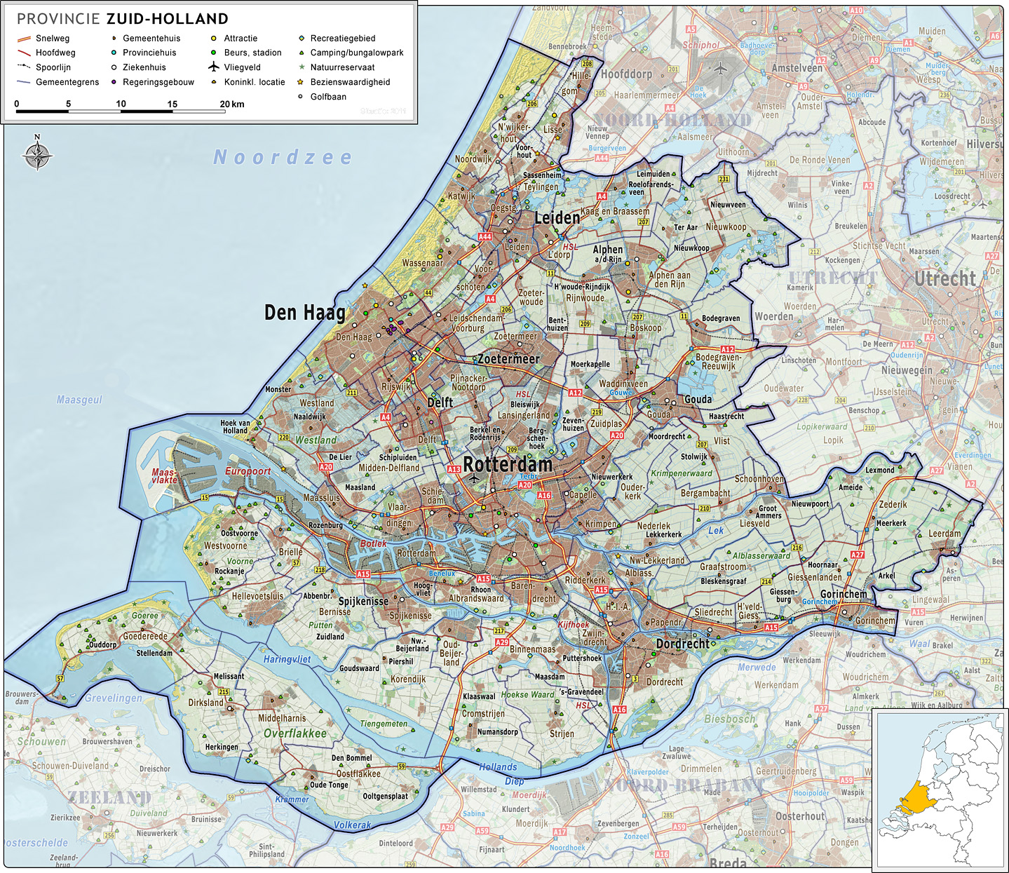
Nederlands: Provincie Zuid-Holland, met indeling van gemeenten (2011) en impressie van het landschap.
Door Jan-Willem van Aalst, samengesteld uit publiek beschikbare geo-data:
|
| Թվական | |
| Աղբյուր | Բեռնողի սեփական աշխատանք |
| Հեղինակ | Janwillemvanaalst |
| Այլ մեկնակերպներ | 2009-Basisbeeld-Provincie08-Zuid-Holland.jpg; 2010-P08-Zuid-Holland-basisbeeld.jpg |
Արտոնագրում
Ես, սույն աշխատանքի հեղինակային իրավունքների տերը, այսուհետ այն հրատարակում եմ հետևյալ արտոնագրի ներքո։
Այս նիշքը հասանելի է Creative Commons Attribution-Share Alike 3.0 Unported արտոնագրի ներքո:
- Դուք ազատ եք՝
- կիսվել ստեղծագործությամբ – պատճենել, տարածել և փոխանցել այս աշխատանքը։
- վերափոխել – ադապտացնել աշխատանքը
- Պահպանելով հետևյալ պայմանները'
- հղում – Դուք պետք է նշեք հեղինակի (իրավատիրոջ) հղումը:
- համանման տարածում – Եթե դուք ձևափոխում եք, փոխակերպում, կամ այս աշխատանքի հիման վրա ստեղծում եք նոր աշխատանք, ապա ձեր ստեղծածը կարող է տարածվել միայն նույն կամ համարժեք թույլատրագրով։
Նիշքի պատմություն
Մատնահարեք օրվան/ժամին՝ նիշքի այդ պահին տեսքը դիտելու համար։
| Օր/Ժամ | Մանրապատկեր | Օբյեկտի չափը | Մասնակից | Մեկնաբանություն | |
|---|---|---|---|---|---|
| ընթացիկ | 07:01, 15 Մայիսի 2011 | | 1439 × 1245 (1,1 ՄԲ) | Janwillemvanaalst | Revision of sea and coastline; updated infrastructure (local roads) and points of interest (new hospitals a.o.) |
| 07:15, 24 Ապրիլի 2011 |  | 1367 × 1183 (1,01 ՄԲ) | Janwillemvanaalst | Updates of names, recreation locations, removed some polyclinical locations | |
| 17:00, 9 Մարտի 2011 |  | 1363 × 1183 (1021 ԿԲ) | Janwillemvanaalst | Added public health services; added regional road labels (N-roads) | |
| 19:08, 23 փետրվարի 2011 |  | 1384 × 1204 (1015 ԿԲ) | Janwillemvanaalst | Added local airports; Added Golf courses; Added major city parks. | |
| 08:48, 13 փետրվարի 2011 |  | 1363 × 1183 (994 ԿԲ) | Janwillemvanaalst | Various map updates and some omissions corrected. Added various tourist locations. | |
| 11:19, 31 Դեկտեմբերի 2010 |  | 1291 × 1121 (965 ԿԲ) | Janwillemvanaalst | {{Information |Description={{nl|1=Provincie Zuid-Holland, met indeling van gemeenten (2011) en impressie van het landschap. Door Jan-Willem van Aalst, samengesteld uit publiek beschikbare geo-data: * Referentie-ondergrond (kustlijn, steden, wegen) geraste |
Նիշքի օգտագործում
Այս նիշքին օգտագործող էջեր չկան։
Նիշքի համընդհանուր օգտագործում
Հետևյալ այլ վիքիները օգտագործում են այս նիշքը՝
- Օգտագործումը ceb.wikipedia.org կայքում
- Օգտագործումը de.wikivoyage.org կայքում
- Օգտագործումը zh.wikipedia.org կայքում