
Պատկեր:2011-2016 Life Expectancy map for India by states.svg

Սկզբնական նիշք (SVG-նիշք, անվանապես 1578 × 1738 փիքսել, նիշքի չափը՝ 863 ԿԲ)
Ամփոփում
| Նկարագրում |
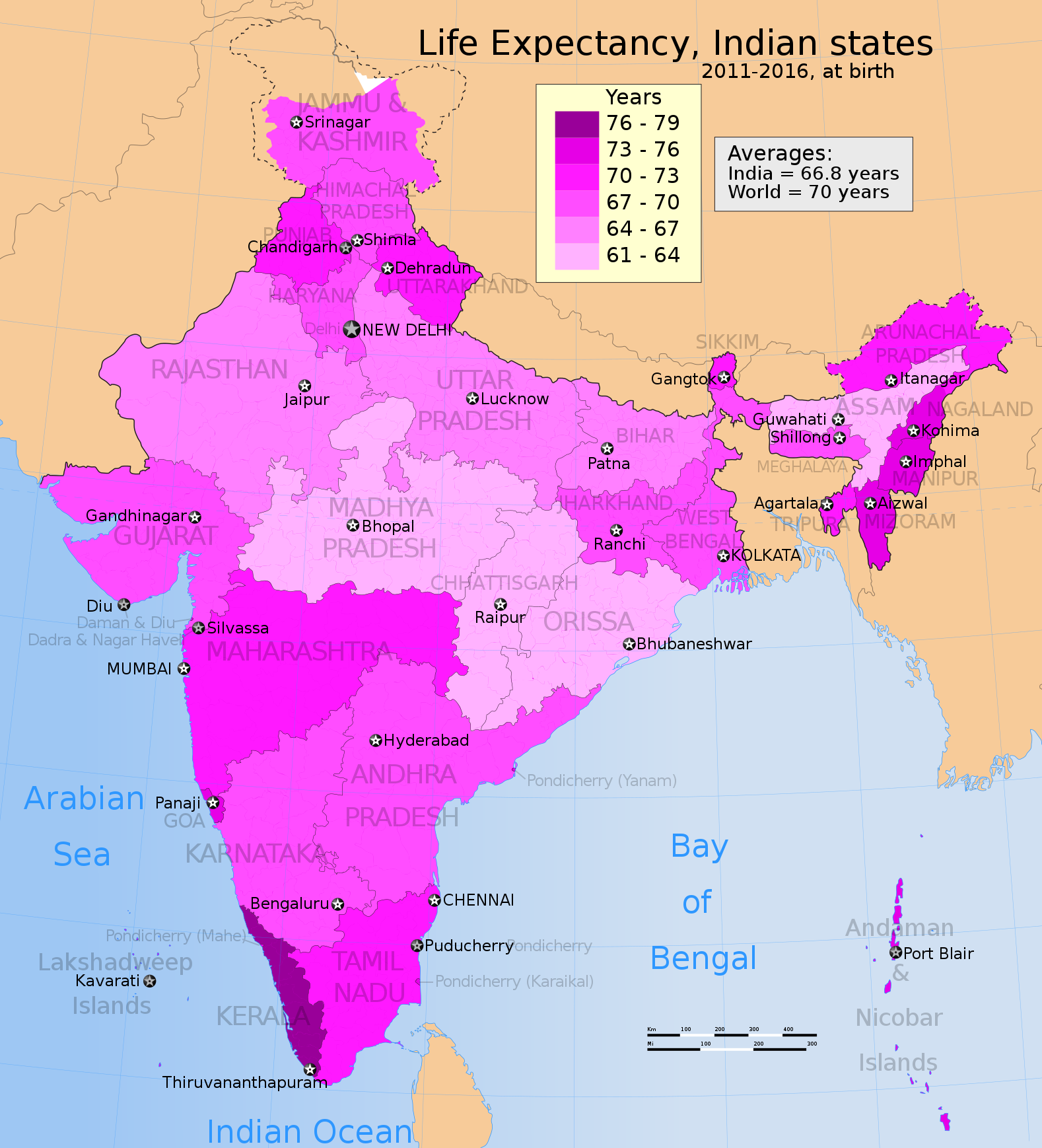
English: The map shows expected life at birth for all states and union territories of India. The data in this map, is an estimated average for the period for 2011-2016 period, just like all past state/UT data for India's demographic life expectancy in 4 or 5 year periods between 1981-2010.
Data sources: 1. Data for states and union territories is from Ponnapalli et al. (2013), Aging and the Demographic Transition in India and Its States: A Comparative Perspective, International Journal of Asian Social Science, 3(1), pp. 171-193 2. The above data table has been verified with The Future Population of India Population Research Bureau and Population Fund of India. Both scenario A and B in this report, and Ponnapalli paper, give the same color map above for 2011-2016 period. The average life expectancy, for all of India, is 66.8 years over this 5 year period. 3. The world's average life expectancy in the map is from World Health Organization (WHO). Quote - "In 2012, life expectancy at birth for both sexes globally was 70 years, ranging from 62 years in low-income countries to 79 years in high-income countries, giving a ratio of 1.3 between the two income groups. Women live longer than men all around the world. The gap in life expectancy between the sexes was 5 years in 1990 and had remained the same by 2012. The gap is much larger in high-income countries (more than six years) than in low-income countries (around three years)." 4. According to WHO, the average life expectancy for all of India in 2012 was 66 years (Reference database Accessed in July 2014) The disputed national borders SVG code used to create this map is a derivative work of File:India literacy rate map en.svg available on wikimedia commons. |
| Թվական | |
| Աղբյուր | Բեռնողի սեփական աշխատանք |
| Հեղինակ | M Tracy Hunter |
Արտոնագրում
- Դուք ազատ եք՝
- կիսվել ստեղծագործությամբ – պատճենել, տարածել և փոխանցել այս աշխատանքը։
- վերափոխել – ադապտացնել աշխատանքը
- Պահպանելով հետևյալ պայմանները'
- հղում – Դուք պետք է նշեք հեղինակի (իրավատիրոջ) հղումը:
- համանման տարածում – Եթե դուք ձևափոխում եք, փոխակերպում, կամ այս աշխատանքի հիման վրա ստեղծում եք նոր աշխատանք, ապա ձեր ստեղծածը կարող է տարածվել միայն նույն կամ համարժեք թույլատրագրով։
Նիշքի պատմություն
Մատնահարեք օրվան/ժամին՝ նիշքի այդ պահին տեսքը դիտելու համար։
| Օր/Ժամ | Մանրապատկեր | Օբյեկտի չափը | Մասնակից | Մեկնաբանություն | |
|---|---|---|---|---|---|
| ընթացիկ | 14:24, 3 Հուլիսի 2014 | | 1578 × 1738 (863 ԿԲ) | M Tracy Hunter | User created page with UploadWizard |
Նիշքի օգտագործում
Հետևյալ էջը հղվում է այս նիշքին՝
Նիշքի համընդհանուր օգտագործում
Հետևյալ այլ վիքիները օգտագործում են այս նիշքը՝
- Օգտագործումը ar.wikipedia.org կայքում
- Օգտագործումը de.wikipedia.org կայքում
- Օգտագործումը el.wikipedia.org կայքում
- Օգտագործումը en.wikipedia.org կայքում
- Օգտագործումը hi.wikipedia.org կայքում
- Օգտագործումը vi.wikipedia.org կայքում