
Պատկեր:2006 North Korean nuclear test.svg

Size of this PNG preview of this SVG file: 473 × 408 պիքսել. Այլ թույլտվությաններ: 278 × 240 պիքսել | 557 × 480 պիքսել | 890 × 768 պիքսել | 1187 × 1024 պիքսել | 2374 × 2048 պիքսել.
Սկզբնական նիշք (SVG-նիշք, անվանապես 473 × 408 փիքսել, նիշքի չափը՝ 71 ԿԲ)
Ամփոփում
| Նկարագրում |
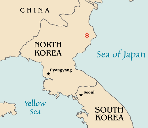
Map of the North Korean nuclear test of October 9, 2006. The red marker indicates the estimated location of the test (41.311°N, 129.114°E). Based off of maps from the CIA World Factbook. |
| Թվական | 10 Հոկտեմբեր 2006 (original upload date) |
| Աղբյուր | No machine-readable source provided. Own work assumed (based on copyright claims). |
| Հեղինակ | No machine-readable author provided. Mobius assumed (based on copyright claims). |
| Այլ մեկնակերպներ |
|


Արտոնագրում
| I, the copyright holder of this work, release this work into the public domain. This applies worldwide. In some countries this may not be legally possible; if so: I grant anyone the right to use this work for any purpose, without any conditions, unless such conditions are required by law. |
Նիշքի պատմություն
Մատնահարեք օրվան/ժամին՝ նիշքի այդ պահին տեսքը դիտելու համար։
| Օր/Ժամ | Մանրապատկեր | Օբյեկտի չափը | Մասնակից | Մեկնաբանություն | |
|---|---|---|---|---|---|
| ընթացիկ | 20:48, 10 Հոկտեմբերի 2006 | | 473 × 408 (71 ԿԲ) | Mobius | + Crop area, proper license |
| 20:43, 10 Հոկտեմբերի 2006 |  | 981 × 801 (71 ԿԲ) | Mobius | Map of the North Korean nuclear test of October 9, 2006. The red marker indicates the estimated location of the test (41.311°N, 129.114°E). Based off of maps from the CIA World Factbook. |
Նիշքի օգտագործում
Այս նիշքին օգտագործող էջեր չկան։
Նիշքի համընդհանուր օգտագործում
Հետևյալ այլ վիքիները օգտագործում են այս նիշքը՝
- Օգտագործումը ca.wikipedia.org կայքում
- Օգտագործումը en.wikipedia.org կայքում
- Օգտագործումը ia.wikipedia.org կայքում
- Օգտագործումը ko.wikipedia.org կայքում
- Օգտագործումը nl.wikipedia.org կայքում
- Օգտագործումը no.wikipedia.org կայքում
- Օգտագործումը pl.wikinews.org կայքում
- Օգտագործումը ta.wikinews.org կայքում
- Օգտագործումը www.wikidata.org կայքում