
Պատկեր:Nansen Greenland Crossing Map.png

Նախադիտման չափ՝ 550 × 599 պիքսել։ Այլ թույլտվությաններ: 220 × 240 պիքսել | 626 × 682 պիքսել.
Սկզբնական նիշք (626 × 682 փիքսել, նիշքի չափը՝ 55 ԿԲ, MIME-տեսակը՝ image/png)
Ամփոփում
| Նկարագրում |
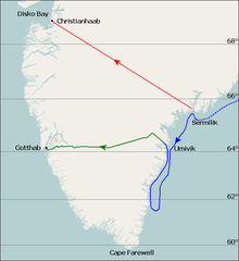
English: Map of Fridtjof Nansen's 1888 route across Greenland, the first crossing of the island.
Dotted line is the ship Jason's journey from Iceland to near Sermilik fjord (now known as Sermiligaaq), continuous blue line is the journey made by Nansen and his companions in two small boats trying to reach the coast. Planned journey from Sermilik northwest to Christianhaab (today known as Qasigiannguit). Nansen's actual journey across Greenland from Umivik fjord to Gothaab (today known as Nuuk). Deutsch: Die gepunktete Linie zeigt die Fahrt der Jason bis zum 17. Juli. Die durchgezogene Linie zeigt die Eisdrift bis zum 29. Juli und die Küstenwanderung bis zum 11. August. Die ursprünglich geplante Route von Sermilik nach Christianshåb. Die wirkliche Route vom 15. August bis 3. Oktober. |
| Թվական | |
| Աղբյուր | Base map is File:Location map Greenland Southern.png, sea (blue) and land (green) journey lines based on File:NansenGreenlandrevisedMap.jpg, published 1888. Latitude lines based on Google Earth sateliite photos. |
| Հեղինակ | Base map is from OpenStreetMap by User:Dr. Blofeld, labels, latitude lines, and journey lines added by Ruhrfisch (talk) |
| Իրավունքներ (Նիշքի վերաօգտագործումը) |
GFDL, CC-BY-SA |
| Այլ մեկնակերպներ |
 |
Արտոնագրում
Ես, այս աշխատանքի հեղինակային իրավունքների տերը, ներկա հրատարակում եմ սրա հետևյալ լիցենզիաների պայմաններով

|
Այս վավերագրման պատճենահանման, տարածման և/կամ ձևափոխման թույլտվություն կամ լիցենզիայի GNU FDL պայմաններով 1.2 մեկնակերպի կամ ավելի ուշ, հրատարակված Ազատ ծրագրային ապահովության հիմնադրամում, առանց անփոփոխելի հատվածների, առանց բնագիրների, որոնք տեղադրված են առաջին և վերջին շապիկներում: Լիցենզիայի պատճենը գտնվում է GNU Free Documentation License հատվածում: |
This file is licensed under the Creative Commons Attribution-Share Alike Attribution-Share Alike 4.0 International, 3.0 Unported, 2.5 Generic, 2.0 Generic and 1.0 Generic license.
- Դուք ազատ եք՝
- կիսվել ստեղծագործությամբ – պատճենել, տարածել և փոխանցել այս աշխատանքը։
- վերափոխել – ադապտացնել աշխատանքը
- Պահպանելով հետևյալ պայմանները'
- հղում – Դուք պետք է նշեք հեղինակի (իրավատիրոջ) հղումը:
- համանման տարածում – Եթե դուք ձևափոխում եք, փոխակերպում, կամ այս աշխատանքի հիման վրա ստեղծում եք նոր աշխատանք, ապա ձեր ստեղծածը կարող է տարածվել միայն նույն կամ համարժեք թույլատրագրով։
Կարող եք ընտրել այս թույլատրագրերից ցանկացածը։
Նիշքի պատմություն
Մատնահարեք օրվան/ժամին՝ նիշքի այդ պահին տեսքը դիտելու համար։
| Օր/Ժամ | Մանրապատկեր | Օբյեկտի չափը | Մասնակից | Մեկնաբանություն | |
|---|---|---|---|---|---|
| ընթացիկ | 21:08, 7 Օգոստոսի 2010 | | 626 × 682 (55 ԿԲ) | Ruhrfisch | Extend green line along fjord to Godthab, make blue line dotted at first. All other information is the same. |
| 14:54, 7 Օգոստոսի 2010 |  | 626 × 682 (55 ԿԲ) | Ruhrfisch | {{Information |Description= Map of Fridtjof Nansen's 1888 route across Greenland, the first crosing of the island. Ocean journey is blue, land journey is green, proposed original journey route is red. |Source= Base map is [[:File:Location map Greenland So |
Նիշքի օգտագործում
Հետևյալ էջը հղվում է այս նիշքին՝
Նիշքի համընդհանուր օգտագործում
Հետևյալ այլ վիքիները օգտագործում են այս նիշքը՝
- Օգտագործումը ba.wikipedia.org կայքում
- Օգտագործումը be.wikipedia.org կայքում
- Օգտագործումը bg.wikipedia.org կայքում
- Օգտագործումը de.wikipedia.org կայքում
- Օգտագործումը en.wikipedia.org կայքում
- Օգտագործումը eo.wikipedia.org կայքում
- Օգտագործումը es.wikipedia.org կայքում
- Օգտագործումը fr.wikipedia.org կայքում
- Օգտագործումը he.wikipedia.org կայքում
- Օգտագործումը hr.wikipedia.org կայքում
- Օգտագործումը id.wikipedia.org կայքում
- Օգտագործումը nn.wikipedia.org կայքում
- Օգտագործումը pt.wikipedia.org կայքում
- Օգտագործումը ro.wikipedia.org կայքում
- Օգտագործումը rue.wikipedia.org կայքում
- Օգտագործումը ru.wikipedia.org կայքում
- Օգտագործումը sl.wikipedia.org կայքում
- Օգտագործումը ta.wikipedia.org կայքում
- Օգտագործումը uk.wikipedia.org կայքում