
Պատկեր:1646linemap.jpg
Ավելի բարձր կետաչափով տարբերակ չկա։
1646linemap.jpg (300 × 250 փիքսել, նիշքի չափը՝ 19 ԿԲ, MIME-տեսակը՝ image/jpeg)

|
This map image could be re-created using vector graphics as an SVG file. This has several advantages; see Commons:Media for cleanup for more information. If an SVG form of this image is available, please upload it and afterwards replace this template with
{{vector version available|new image name}}.
It is recommended to name the SVG file “1646linemap.svg”—then the template Vector version available (or Vva) does not need the new image name parameter. |


Ամփոփում
| Նկարագրում |
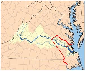
English: Self-Made from Jamesrivermap.jpg, red line shows boundary between Virginia Colony and Tributary Indian tribes as established by Treaty of 1646 concluding Second Anglo-Powhatan War. Red dot on river shows Jamestown, capital of Virginia Colony. |
| Թվական | 10 Մարտ 2009 (original upload date) |
| Աղբյուր | Transferred from en.wikipedia to Commons by The Bushranger using CommonsHelper. |
| Հեղինակ | Til Eulenspiegel at անգլերեն Վիքիպեդիա |
Արտոնագրում
| This work has been released into the public domain by its author, Til Eulenspiegel at անգլերեն Վիքիպեդիա. This applies worldwide. In some countries this may not be legally possible; if so: Til Eulenspiegel grants anyone the right to use this work for any purpose, without any conditions, unless such conditions are required by law. |
Original upload log
The original description page was here. All following user names refer to en.wikipedia.
- 2009-03-10 13:56 Til Eulenspiegel 300×250 (19099 bytes) Self-Made from Jamesrivermap.jpg, red line shows boundary between [[Virginia Colony]] and Tributary Indian tribes as established by Treaty of 1646 concluding [[Second Anglo-Powhatan War]]. Red dot shows Jamestown, capital of Virginia Colony.
Նիշքի պատմություն
Մատնահարեք օրվան/ժամին՝ նիշքի այդ պահին տեսքը դիտելու համար։
| Օր/Ժամ | Մանրապատկեր | Օբյեկտի չափը | Մասնակից | Մեկնաբանություն | |
|---|---|---|---|---|---|
| ընթացիկ | 15:56, 1 հունվարի 2012 | | 300 × 250 (19 ԿԲ) | File Upload Bot (Magnus Manske) | {{BotMoveToCommons|en.wikipedia|year={{subst:CURRENTYEAR}}|month={{subst:CURRENTMONTHNAME}}|day={{subst:CURRENTDAY}}}} {{Information |Description={{en|Self-Made from Jamesrivermap.jpg, red line shows boundary between en:Virginia Colony and Tributar |
Նիշքի օգտագործում
Հետևյալ 2 էջերը հղվում են այս նիշքին՝
Նիշքի համընդհանուր օգտագործում
Հետևյալ այլ վիքիները օգտագործում են այս նիշքը՝
- Օգտագործումը en.wikipedia.org կայքում
- Օգտագործումը fr.wikipedia.org կայքում