
Պատկեր:River Trent.png
Ավելի բարձր կետաչափով տարբերակ չկա։
River_Trent.png (559 × 437 փիքսել, նիշքի չափը՝ 61 ԿԲ, MIME-տեսակը՝ image/png)
| Նկարագրում |
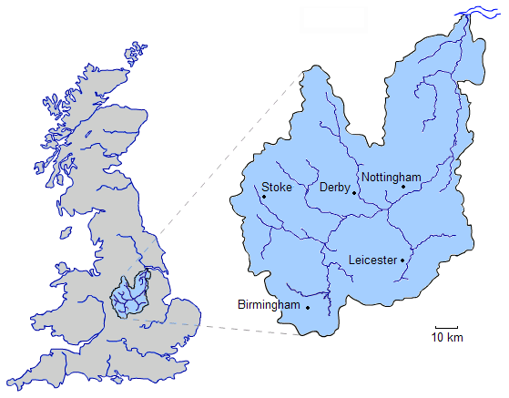
English: The River Trent is one of the major rivers of England. Its source is in Staffordshire between Biddulph and Biddulph Moor. It flows through the Midlands (forming a once-significant boundary between the North and South of England) until it joins the River Ouse at Trent Falls to form the Humber Estuary, which empties into the North Sea between Hull and Immingham. |
||
| Թվական | (UTC) | ||
| Աղբյուր | Բեռնողի սեփական աշխատանք | ||
| Հեղինակ | Jrockley | ||
| Իրավունքներ (Նիշքի վերաօգտագործումը) |
|
Նիշքի պատմություն
Մատնահարեք օրվան/ժամին՝ նիշքի այդ պահին տեսքը դիտելու համար։
| Օր/Ժամ | Մանրապատկեր | Օբյեկտի չափը | Մասնակից | Մեկնաբանություն | |
|---|---|---|---|---|---|
| ընթացիկ | 23:37, 12 Օգոստոսի 2008 | | 559 × 437 (61 ԿԲ) | Jrockley | blue estuary |
| 23:31, 12 Օգոստոսի 2008 |  | 559 × 437 (39 ԿԲ) | Jrockley | {{Information |Description={{en|1=The '''River Trent''' is one of the major rivers of England. Its source is in Staffordshire between Biddulph and Biddulph Moor. It flows through the Midlands (forming a once-significant boundary between |
Նիշքի օգտագործում
Հետևյալ էջը հղվում է այս նիշքին՝
Նիշքի համընդհանուր օգտագործում
Հետևյալ այլ վիքիները օգտագործում են այս նիշքը՝
- Օգտագործումը ar.wikipedia.org կայքում
- Օգտագործումը azb.wikipedia.org կայքում
- Օգտագործումը bg.wikipedia.org կայքում
- Օգտագործումը bn.wikipedia.org կայքում
- Օգտագործումը br.wikipedia.org կայքում
- Օգտագործումը cs.wikipedia.org կայքում
- Օգտագործումը cv.wikipedia.org կայքում
- Օգտագործումը de.wikipedia.org կայքում
- Օգտագործումը en.wikipedia.org կայքում
- Օգտագործումը es.wikipedia.org կայքում
- Օգտագործումը fi.wikipedia.org կայքում
- Օգտագործումը fr.wikipedia.org կայքում
- Օգտագործումը fy.wikipedia.org կայքում
- Օգտագործումը lld.wikipedia.org կայքում
- Օգտագործումը nn.wikipedia.org կայքում
- Օգտագործումը no.wikipedia.org կայքում
- Օգտագործումը pl.wikipedia.org կայքում
- Օգտագործումը pt.wikipedia.org կայքում
- Օգտագործումը ru.wikipedia.org կայքում
- Օգտագործումը simple.wikipedia.org կայքում
- Օգտագործումը sr.wikipedia.org կայքում
- Օգտագործումը sv.wikipedia.org կայքում
- Օգտագործումը tr.wikipedia.org կայքում
- Օգտագործումը uk.wikipedia.org կայքում
- Օգտագործումը www.wikidata.org կայքում
- Օգտագործումը xmf.wikipedia.org կայքում
- Օգտագործումը zh.wikipedia.org կայքում