
Պատկեր:Byzantine empire 1355.jpg

Նախադիտման չափ՝ 758 × 600 պիքսել։ Այլ թույլտվությաններ: 304 × 240 պիքսել | 607 × 480 պիքսել | 971 × 768 պիքսել | 1134 × 897 պիքսել.
Սկզբնական նիշք (1134 × 897 փիքսել, նիշքի չափը՝ 380 ԿԲ, MIME-տեսակը՝ image/jpeg)
Ամփոփում
| Նկարագրում |
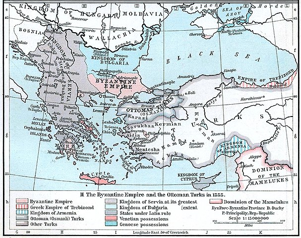
English: Map of the Byzantine, Ottoman and Serbian empires and their neighboring states, 1355. |
||||||||||||||||||||||
| Թվական | |||||||||||||||||||||||
| Աղբյուր | William R. Shepherd's Historical Atlas, p. 89, published by Henry Holt and Company, New York 1911 | ||||||||||||||||||||||
| Հեղինակ |
|
||||||||||||||||||||||
| Այլ մեկնակերպներ |
|
||||||||||||||||||||||

Արտոնագրում
This work is in the public domain in the United States because it was published (or registered with the U.S. Copyright Office) before January 1, 1929.
Public domain works must be out of copyright in both the United States and in the source country of the work in order to be hosted on the Commons. If the work is not a U.S. work, the file must have an additional copyright tag indicating the copyright status in the source country.
Note: This tag should not be used for sound recordings. |
Նիշքի պատմություն
Մատնահարեք օրվան/ժամին՝ նիշքի այդ պահին տեսքը դիտելու համար։
| Օր/Ժամ | Մանրապատկեր | Օբյեկտի չափը | Մասնակից | Մեկնաբանություն | |
|---|---|---|---|---|---|
| ընթացիկ | 20:53, 6 Դեկտեմբերի 2022 | | 1134 × 897 (380 ԿԲ) | Gyalu22 | Artwork |
| 16:44, 29 Մարտի 2018 |  | 1112 × 879 (908 ԿԲ) | Nihil scimus | Few improving (esthetic, contrast, genoese possessions 1355 since Westermann Grosser Atlas zur Weltgeschichte, 1985, ISBN 3-14-100919-8, p. 70, wallachian possessions 1355 under Nicholas Alexander [https://commons.wikimedia.org/wiki/File:Nicolae_Alexandru.jpg] since [https://en.wikipedia.org/wiki/Wallachia#/media/File:Wallachia_13-16c.svg]). | |
| 13:17, 8 Նոյեմբերի 2009 |  | 1134 × 897 (380 ԿԲ) | Alex:D | whitened | |
| 16:00, 3 Դեկտեմբերի 2005 |  | 1134 × 897 (269 ԿԲ) | Migdejong | Map of the Byzantine Empire in the year 1355. Image comes from the University of Texas at Austin: http://geography.about.com/gi/dynamic/offsite.htm?site=http://www.lib.utexas.edu/maps/historical/history%5Feurope.html Map is released into the public |
Նիշքի օգտագործում
Հետևյալ էջը հղվում է այս նիշքին՝
Նիշքի համընդհանուր օգտագործում
Հետևյալ այլ վիքիները օգտագործում են այս նիշքը՝
- Օգտագործումը ar.wikipedia.org կայքում
- Օգտագործումը azb.wikipedia.org կայքում
- Օգտագործումը az.wikipedia.org կայքում
- Օգտագործումը ba.wikipedia.org կայքում
- Օգտագործումը bg.wikipedia.org կայքում
- Օգտագործումը bs.wikipedia.org կայքում
- Օգտագործումը ca.wikipedia.org կայքում
- Օգտագործումը de.wikipedia.org կայքում
- Byzantinisches Reich
- Makedonien
- 1355
- Großserbien
- Marino Falier
- Andronikos IV.
- Beylik von Aydın
- Eroberung von Philadelphia
- Eroberung von Gallipoli
- Byzantinisch-genuesischer Krieg (1348–1349)
- Byzantinischer Bürgerkrieg (1352–1357)
- Byzantinischer Bürgerkrieg (1373–1381)
- Kreuzzug von Smyrna
- Benutzer:GerardM/Battles including the Ottoman Empire
- Օգտագործումը el.wikipedia.org կայքում
- Օգտագործումը en.wikipedia.org կայքում
Տեսնել այս նիշքի ավելի համընդհանուր օգտագործումը: