
Պատկեր:BlueLine.jpg
Նախադիտման չափ՝ 800 × 553 պիքսել։ Այլ թույլտվությաններ: 320 × 221 պիքսել | 640 × 442 պիքսել | 1024 × 708 պիքսել | 1299 × 898 պիքսել.
Սկզբնական նիշք (1299 × 898 փիքսել, նիշքի չափը՝ 157 ԿԲ, MIME-տեսակը՝ image/jpeg)
Ամփոփում
| Նկարագրում |
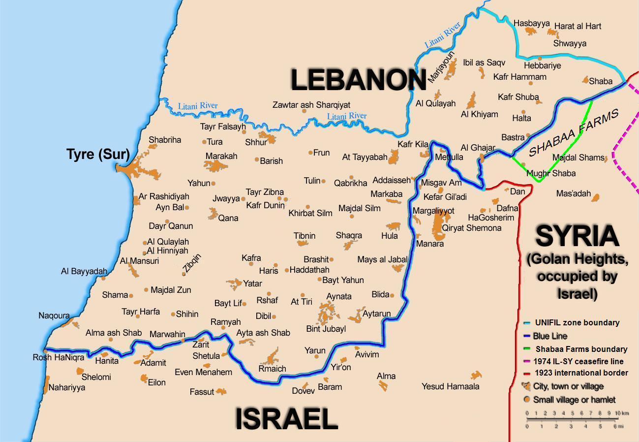
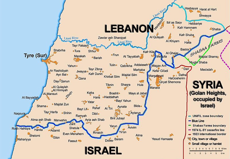
English: Map showing the Blue Line demarcation line between Lebanon and Israel, established by the UN after the Israeli withdrawal from southern Lebanon after its short 1978 invasion called Operation Litani. It follows the 1949 cease-fire line, also known as the Green Line, as well as the somewhat contested Lebanese-Syrian border towards the Israeli-occupied Golan Heights. |
| Թվական | short 1978 the 1949 July 2006 the 2006 |
| Աղբյուր | Self-published work by 99of9 |
| Հեղինակ | 99of9 / * The map is made by Thomas Blomberg using the UNIFIL map, deployment as of July 2006 as source. |
| Այլ մեկնակերպներ |
|


|
This map image could be re-created using vector graphics as an SVG file. This has several advantages; see Commons:Media for cleanup for more information. If an SVG form of this image is available, please upload it and afterwards replace this template with
{{vector version available|new image name}}.
It is recommended to name the SVG file “BlueLine.svg”—then the template Vector version available (or Vva) does not need the new image name parameter. |


Արտոնագրում
Ես, սույն աշխատանքի հեղինակային իրավունքների տերը, այսուհետ այն հրատարակում եմ հետևյալ արտոնագրի ներքո։
This file is licensed under the Creative Commons Attribution-Share Alike 2.5 Generic license.
- Դուք ազատ եք՝
- կիսվել ստեղծագործությամբ – պատճենել, տարածել և փոխանցել այս աշխատանքը։
- վերափոխել – ադապտացնել աշխատանքը
- Պահպանելով հետևյալ պայմանները'
- հղում – Դուք պետք է նշեք հեղինակի (իրավատիրոջ) հղումը:
- համանման տարածում – Եթե դուք ձևափոխում եք, փոխակերպում, կամ այս աշխատանքի հիման վրա ստեղծում եք նոր աշխատանք, ապա ձեր ստեղծածը կարող է տարածվել միայն նույն կամ համարժեք թույլատրագրով։
Նիշքի պատմություն
Մատնահարեք օրվան/ժամին՝ նիշքի այդ պահին տեսքը դիտելու համար։
| Օր/Ժամ | Մանրապատկեր | Օբյեկտի չափը | Մասնակից | Մեկնաբանություն | |
|---|---|---|---|---|---|
| ընթացիկ | 10:44, 16 Նոյեմբերի 2010 | | 1299 × 898 (157 ԿԲ) | 99of9 | Reverted to version as of 20:09, 21 October 2010. These boundaries appear to be accepted by both "sides" of the war. Their difference is over the label SYRIA (occupied...) over Golan Heights. For that we are now consistent with the original uploader's |
| 20:09, 21 Հոկտեմբերի 2010 |  | 1299 × 898 (157 ԿԲ) | Nableezy | keep boundary changes but restore label for syria | |
| 16:30, 17 Օգոստոսի 2006 |  | 1299 × 898 (238 ԿԲ) | Thomas Blomberg | ||
| 14:16, 4 Օգոստոսի 2006 |  | 1299 × 898 (643 ԿԲ) | Thomas Blomberg | Map showing the Blue Line demarkation line between Lebanon and Israel, established by the UN after the Israeli withdrawal from southern Lebanon after its short 1978 invasion called "Operation Litani". It follows the 1949 cease-fire line, also known as the |
Նիշքի օգտագործում
Հետևյալ 2 էջերը հղվում են այս նիշքին՝
Նիշքի համընդհանուր օգտագործում
Հետևյալ այլ վիքիները օգտագործում են այս նիշքը՝
- Օգտագործումը ar.wikipedia.org կայքում
- Օգտագործումը ast.wikipedia.org կայքում
- Օգտագործումը azb.wikipedia.org կայքում
- Օգտագործումը ca.wikipedia.org կայքում
- Operació Litani
- Conflicte Israel-Líban
- Història del Líban
- Resolució 262 del Consell de Seguretat de les Nacions Unides
- Resolució 279 del Consell de Seguretat de les Nacions Unides
- Resolució 313 del Consell de Seguretat de les Nacions Unides
- Resolució 317 del Consell de Seguretat de les Nacions Unides
- Resolució 337 del Consell de Seguretat de les Nacions Unides
- Resolució 427 del Consell de Seguretat de les Nacions Unides
- Resolució 425 del Consell de Seguretat de les Nacions Unides
- Resolució 434 del Consell de Seguretat de les Nacions Unides
- Resolució 444 del Consell de Seguretat de les Nacions Unides
- Resolució 501 del Consell de Seguretat de les Nacions Unides
- Resolució 519 del Consell de Seguretat de les Nacions Unides
- Resolució 659 del Consell de Seguretat de les Nacions Unides
- Resolució 938 del Consell de Seguretat de les Nacions Unides
- Resolució 1122 del Consell de Seguretat de les Nacions Unides
- Resolució 1525 del Consell de Seguretat de les Nacions Unides
- Resolució 1655 del Consell de Seguretat de les Nacions Unides
- Resolució 1697 del Consell de Seguretat de les Nacions Unides
- Resolució 1773 del Consell de Seguretat de les Nacions Unides
- Օգտագործումը ckb.wikipedia.org կայքում
- بڕیارنامەی ٤٢٦ی ئەنجومەنی ئاسایش
- بڕیارنامەی ٤٢٧ی ئەنجومەنی ئاسایش
- بڕیارنامەی ٤٣٤ی ئەنجومەنی ئاسایش
- بڕیارنامەی ٤٤٤ی ئەنجومەنی ئاسایش
- بڕیارنامەی ٥٠١ی ئەنجومەنی ئاسایش
- بڕیارنامەی ٥١١ی ئەنجومەنی ئاسایش
- بڕیارنامەی ٥١٩ی ئەنجومەنی ئاسایش
- بڕیارنامەی ٦٥٩ی ئەنجومەنی ئاسایش
- بڕیارنامەی ١١٢٢ی ئەنجومەنی ئاسایش
- بڕیارنامەی ١٥٢٥ی ئەنجومەنی ئاسایش
- بڕیارنامەی ١٦٥٥ی ئەنجومەنی ئاسایش
- Օգտագործումը cy.wikipedia.org կայքում
- Օգտագործումը de.wikipedia.org կայքում
- Օգտագործումը el.wikipedia.org կայքում
- Օգտագործումը en.wikipedia.org կայքում
Տեսնել այս նիշքի ավելի համընդհանուր օգտագործումը: